You are here: Home > Network List > TA - USArray Transportable Network (new EarthScope stations) Stations List
> Station J26L Joseph Creek, AK, USA > Earthquake Result Viewer
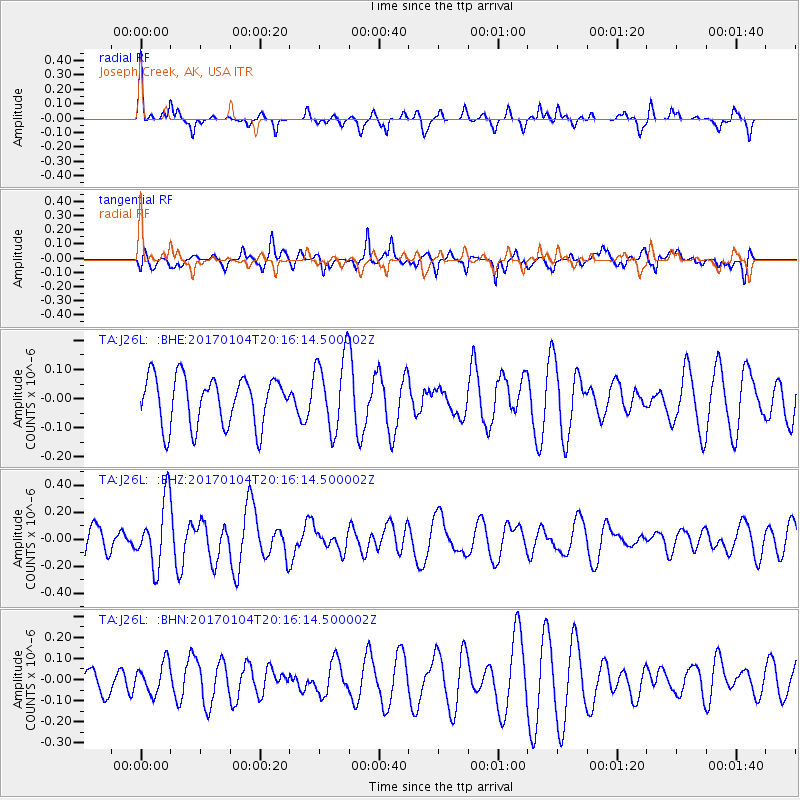
J26L Joseph Creek, AK, USA - Earthquake Result Viewer
*The percent match for this event was below the threshold and hence no stack was calculated.
| Earthquake location: |
Fiji Islands Region |
| Earthquake latitude/longitude: |
-18.8/176.3 |
| Earthquake time(UTC): |
2017/01/04 (004) 20:03:52 GMT |
| Earthquake Depth: |
7.0 km |
| Earthquake Magnitude: |
5.7 Mww |
| Earthquake Catalog/Contributor: |
NEIC PDE/us |
|
| Network: |
TA USArray Transportable Network (new EarthScope stations) |
| Station: |
J26L Joseph Creek, AK, USA |
| Lat/Lon: |
64.50 N/143.56 W |
| Elevation: |
1144 m |
|
| Distance: |
88.6 deg |
| Az: |
16.222 deg |
| Baz: |
217.69 deg |
| Ray Param: |
$rayparam |
*The percent match for this event was below the threshold and hence was not used in the summary stack. |
|
| Radial Match: |
52.27025 % |
| Radial Bump: |
268 |
| Transverse Match: |
60.677376 % |
| Transverse Bump: |
400 |
| SOD ConfigId: |
11737051 |
| Insert Time: |
2019-04-26 13:34:09.557 +0000 |
| GWidth: |
2.5 |
| Max Bumps: |
400 |
| Tol: |
0.001 |
|
Signal To Noise
| Channel | StoN | STA | LTA |
| TA:J26L: :BHZ:20170104T20:16:14.500002Z | 1.6330825 | 2.424917E-7 | 1.484871E-7 |
| TA:J26L: :BHN:20170104T20:16:14.500002Z | 1.0373576 | 7.348003E-8 | 7.083385E-8 |
| TA:J26L: :BHE:20170104T20:16:14.500002Z | 1.5376134 | 1.2831713E-7 | 8.3452136E-8 |
| Arrivals |
| Ps | |
| PpPs | |
| PsPs/PpSs | |


