You are here: Home > Network List > TA - USArray Transportable Network (new EarthScope stations) Stations List
> Station MDND Maddock, ND, USA > Earthquake Result Viewer
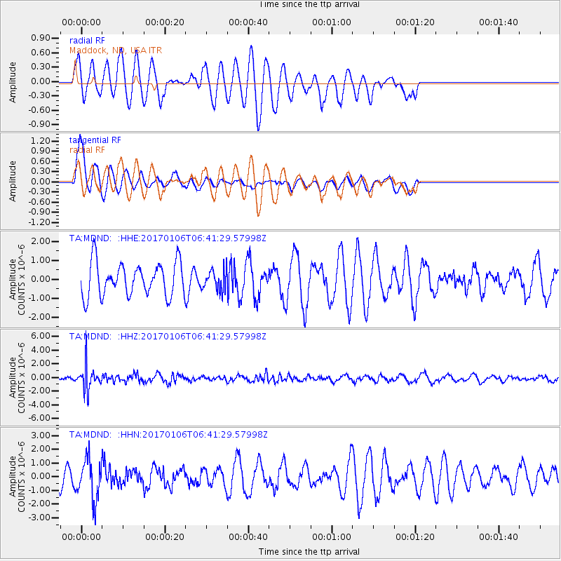
MDND Maddock, ND, USA - Earthquake Result Viewer
*The percent match for this event was below the threshold and hence no stack was calculated.
| Earthquake location: |
Chile-Bolivia Border Region |
| Earthquake latitude/longitude: |
-22.4/-67.7 |
| Earthquake time(UTC): |
2017/01/06 (006) 06:30:33 GMT |
| Earthquake Depth: |
142 km |
| Earthquake Magnitude: |
5.7 mb |
| Earthquake Catalog/Contributor: |
NEIC PDE/us |
|
| Network: |
TA USArray Transportable Network (new EarthScope stations) |
| Station: |
MDND Maddock, ND, USA |
| Lat/Lon: |
47.85 N/99.60 W |
| Elevation: |
479 m |
|
| Distance: |
75.5 deg |
| Az: |
338.419 deg |
| Baz: |
149.635 deg |
| Ray Param: |
$rayparam |
*The percent match for this event was below the threshold and hence was not used in the summary stack. |
|
| Radial Match: |
59.63831 % |
| Radial Bump: |
400 |
| Transverse Match: |
66.28523 % |
| Transverse Bump: |
400 |
| SOD ConfigId: |
11737051 |
| Insert Time: |
2019-04-26 13:42:21.310 +0000 |
| GWidth: |
2.5 |
| Max Bumps: |
400 |
| Tol: |
0.001 |
|
Signal To Noise
| Channel | StoN | STA | LTA |
| TA:MDND: :HHZ:20170106T06:41:29.57998Z | 6.532614 | 1.7963686E-6 | 2.7498461E-7 |
| TA:MDND: :HHN:20170106T06:41:29.57998Z | 2.4695647 | 1.4876312E-6 | 6.02386E-7 |
| TA:MDND: :HHE:20170106T06:41:29.57998Z | 0.7688068 | 6.6010796E-7 | 8.586136E-7 |
| Arrivals |
| Ps | |
| PpPs | |
| PsPs/PpSs | |


