You are here: Home > Network List > CI - Caltech Regional Seismic Network Stations List
> Station BC3 Big Chuckawalla Mtns, Desert Center, CA, USA > Earthquake Result Viewer
BC3 Big Chuckawalla Mtns, Desert Center, CA, USA - Earthquake Result Viewer
| Earthquake location: |
Peru-Ecuador Border Region |
| Earthquake latitude/longitude: |
-2.3/-77.8 |
| Earthquake time(UTC): |
2007/11/16 (320) 03:13:00 GMT |
| Earthquake Depth: |
123 km |
| Earthquake Magnitude: |
6.3 MB, 6.8 MW, 6.7 MW |
| Earthquake Catalog/Contributor: |
WHDF/NEIC |
|
| Network: |
CI Caltech Regional Seismic Network |
| Station: |
BC3 Big Chuckawalla Mtns, Desert Center, CA, USA |
| Lat/Lon: |
33.66 N/115.45 W |
| Elevation: |
1137 m |
|
| Distance: |
50.4 deg |
| Az: |
318.609 deg |
| Baz: |
127.621 deg |
| Ray Param: |
0.06769639 |
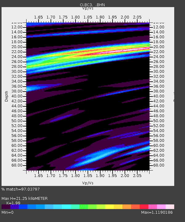
| Estimated Moho Depth: |
21.25 km |
| Estimated Crust Vp/Vs: |
1.99 |
| Assumed Crust Vp: |
6.155 km/s |
| Estimated Crust Vs: |
3.093 km/s |
| Estimated Crust Poisson's Ratio: |
0.33 |
|
| Radial Match: |
97.03797 % |
| Radial Bump: |
331 |
| Transverse Match: |
85.671906 % |
| Transverse Bump: |
400 |
| SOD ConfigId: |
2564 |
| Insert Time: |
2010-03-05 21:22:03.639 +0000 |
| GWidth: |
2.5 |
| Max Bumps: |
400 |
| Tol: |
0.001 |
|

Signal To Noise
| Channel | StoN | STA | LTA |
| CI:BC3: :BHN:20071116T03:21:13.988011Z | 2.291319 | 5.7088727E-7 | 2.4915224E-7 |
| CI:BC3: :BHE:20071116T03:21:13.988011Z | 4.107611 | 7.1741346E-7 | 1.7465466E-7 |
| CI:BC3: :BHZ:20071116T03:21:13.988011Z | 11.961994 | 1.6427484E-6 | 1.3733066E-7 |
| Arrivals |
| Ps | 3.6 SECOND |
| PpPs | 9.9 SECOND |
| PsPs/PpSs | 13 SECOND |


