You are here: Home > Network List > TM - Thai Seismic Monitoring Network Stations List
> Station PHRA PHRA staion > Earthquake Result Viewer
PHRA PHRA staion - Earthquake Result Viewer
| Earthquake location: |
Sumba Region, Indonesia |
| Earthquake latitude/longitude: |
-9.4/120.2 |
| Earthquake time(UTC): |
2017/01/07 (007) 09:11:59 GMT |
| Earthquake Depth: |
78 km |
| Earthquake Magnitude: |
5.6 mb |
| Earthquake Catalog/Contributor: |
NEIC PDE/us |
|
| Network: |
TM Thai Seismic Monitoring Network |
| Station: |
PHRA PHRA staion |
| Lat/Lon: |
18.50 N/100.23 E |
| Elevation: |
187 m |
|
| Distance: |
34.0 deg |
| Az: |
324.553 deg |
| Baz: |
142.907 deg |
| Ray Param: |
0.077749684 |
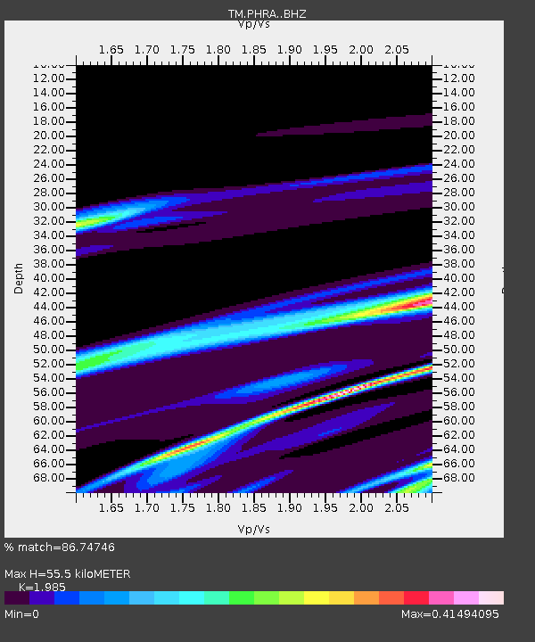
| Estimated Moho Depth: |
55.5 km |
| Estimated Crust Vp/Vs: |
1.99 |
| Assumed Crust Vp: |
6.35 km/s |
| Estimated Crust Vs: |
3.199 km/s |
| Estimated Crust Poisson's Ratio: |
0.33 |
|
| Radial Match: |
86.74746 % |
| Radial Bump: |
197 |
| Transverse Match: |
48.145885 % |
| Transverse Bump: |
259 |
| SOD ConfigId: |
11737051 |
| Insert Time: |
2019-04-26 13:52:34.813 +0000 |
| GWidth: |
2.5 |
| Max Bumps: |
400 |
| Tol: |
0.001 |
|

Signal To Noise
| Channel | StoN | STA | LTA |
| TM:PHRA: :BHZ:20170107T09:18:05.319994Z | 0.18388756 | 2.2730776E-6 | 1.2361236E-5 |
| TM:PHRA: :BHN:20170107T09:18:05.319994Z | 1.6953915 | 6.6375896E-6 | 3.9150777E-6 |
| TM:PHRA: :BHE:20170107T09:18:05.319994Z | 1.6779165 | 6.5552313E-6 | 3.9067686E-6 |
| Arrivals |
| Ps | 9.2 SECOND |
| PpPs | 24 SECOND |
| PsPs/PpSs | 34 SECOND |


