You are here: Home > Network List > UU - University of Utah Regional Network Stations List
> Station CCUT Cedar City, UT, USA > Earthquake Result Viewer
CCUT Cedar City, UT, USA - Earthquake Result Viewer
| Earthquake location: |
Near Coast Of Central Chile |
| Earthquake latitude/longitude: |
-30.9/-71.5 |
| Earthquake time(UTC): |
2015/11/07 (311) 07:31:42 GMT |
| Earthquake Depth: |
36 km |
| Earthquake Magnitude: |
6.8 MWP, 6.8 MI |
| Earthquake Catalog/Contributor: |
NEIC PDE/NEIC COMCAT |
|
| Network: |
UU University of Utah Regional Network |
| Station: |
CCUT Cedar City, UT, USA |
| Lat/Lon: |
37.55 N/113.36 W |
| Elevation: |
2127 m |
|
| Distance: |
78.5 deg |
| Az: |
327.265 deg |
| Baz: |
144.211 deg |
| Ray Param: |
0.049528506 |
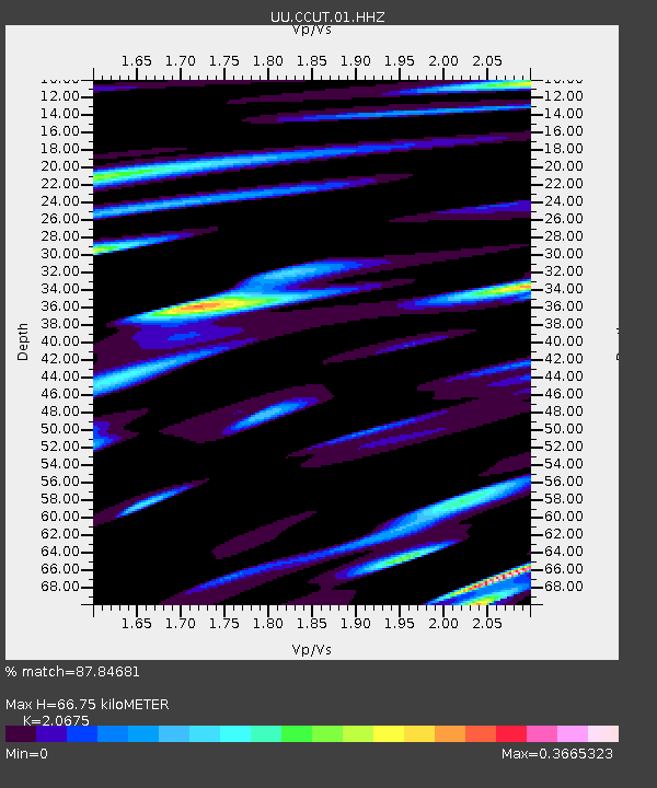
| Estimated Moho Depth: |
66.75 km |
| Estimated Crust Vp/Vs: |
2.07 |
| Assumed Crust Vp: |
6.194 km/s |
| Estimated Crust Vs: |
2.996 km/s |
| Estimated Crust Poisson's Ratio: |
0.35 |
|
| Radial Match: |
87.84681 % |
| Radial Bump: |
369 |
| Transverse Match: |
76.28629 % |
| Transverse Bump: |
361 |
| SOD ConfigId: |
1259291 |
| Insert Time: |
2015-11-21 08:32:39.703 +0000 |
| GWidth: |
2.5 |
| Max Bumps: |
400 |
| Tol: |
0.001 |
|

Signal To Noise
| Channel | StoN | STA | LTA |
| UU:CCUT:01:HHZ:20151107T07:43:09.39001Z | 6.366055 | 4.0209025E-6 | 6.31616E-7 |
| UU:CCUT:01:HHN:20151107T07:43:09.39001Z | 2.367875 | 1.0482732E-6 | 4.4270632E-7 |
| UU:CCUT:01:HHE:20151107T07:43:09.39001Z | 2.6931198 | 9.0193316E-7 | 3.3490272E-7 |
| Arrivals |
| Ps | 12 SECOND |
| PpPs | 32 SECOND |
| PsPs/PpSs | 44 SECOND |


