You are here: Home > Network List > TA - USArray Transportable Network (new EarthScope stations) Stations List
> Station A21K Barrow, AK, USA > Earthquake Result Viewer
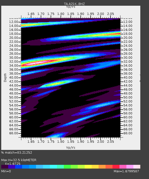
A21K Barrow, AK, USA - Earthquake Result Viewer
| Earthquake location: |
Eastern New Guinea Reg., P.N.G. |
| Earthquake latitude/longitude: |
-6.2/147.5 |
| Earthquake time(UTC): |
2017/01/08 (008) 08:52:08 GMT |
| Earthquake Depth: |
67 km |
| Earthquake Magnitude: |
5.9 Mww |
| Earthquake Catalog/Contributor: |
NEIC PDE/us |
|
| Network: |
TA USArray Transportable Network (new EarthScope stations) |
| Station: |
A21K Barrow, AK, USA |
| Lat/Lon: |
71.32 N/156.62 W |
| Elevation: |
577 m |
|
| Distance: |
85.6 deg |
| Az: |
15.521 deg |
| Baz: |
235.662 deg |
| Ray Param: |
0.044547047 |
| Estimated Moho Depth: |
32.5 km |
| Estimated Crust Vp/Vs: |
1.67 |
| Assumed Crust Vp: |
6.048 km/s |
| Estimated Crust Vs: |
3.616 km/s |
| Estimated Crust Poisson's Ratio: |
0.22 |
|
| Radial Match: |
83.21252 % |
| Radial Bump: |
400 |
| Transverse Match: |
76.94464 % |
| Transverse Bump: |
400 |
| SOD ConfigId: |
11737051 |
| Insert Time: |
2019-04-26 13:57:24.544 +0000 |
| GWidth: |
2.5 |
| Max Bumps: |
400 |
| Tol: |
0.001 |
|

Signal To Noise
| Channel | StoN | STA | LTA |
| TA:A21K: :BHZ:20170108T09:04:08.300007Z | 7.167866 | 6.927793E-7 | 9.66507E-8 |
| TA:A21K: :BHN:20170108T09:04:08.300007Z | 4.7526975 | 5.253063E-7 | 1.10528035E-7 |
| TA:A21K: :BHE:20170108T09:04:08.300007Z | 1.1117086 | 2.3016996E-7 | 2.0704164E-7 |
| Arrivals |
| Ps | 3.7 SECOND |
| PpPs | 14 SECOND |
| PsPs/PpSs | 18 SECOND |


