You are here: Home > Network List > TA - USArray Transportable Network (new EarthScope stations) Stations List
> Station D23K Nanushuk River, AK USA > Earthquake Result Viewer
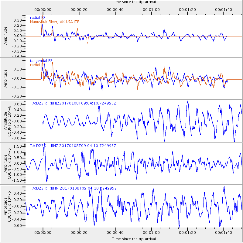
D23K Nanushuk River, AK USA - Earthquake Result Viewer
*The percent match for this event was below the threshold and hence no stack was calculated.
| Earthquake location: |
Eastern New Guinea Reg., P.N.G. |
| Earthquake latitude/longitude: |
-6.2/147.5 |
| Earthquake time(UTC): |
2017/01/08 (008) 08:52:08 GMT |
| Earthquake Depth: |
67 km |
| Earthquake Magnitude: |
5.9 Mww |
| Earthquake Catalog/Contributor: |
NEIC PDE/us |
|
| Network: |
TA USArray Transportable Network (new EarthScope stations) |
| Station: |
D23K Nanushuk River, AK USA |
| Lat/Lon: |
68.97 N/150.68 W |
| Elevation: |
406 m |
|
| Distance: |
86.1 deg |
| Az: |
18.606 deg |
| Baz: |
241.469 deg |
| Ray Param: |
$rayparam |
*The percent match for this event was below the threshold and hence was not used in the summary stack. |
|
| Radial Match: |
55.954903 % |
| Radial Bump: |
389 |
| Transverse Match: |
47.713165 % |
| Transverse Bump: |
400 |
| SOD ConfigId: |
11737051 |
| Insert Time: |
2019-04-26 13:57:24.839 +0000 |
| GWidth: |
2.5 |
| Max Bumps: |
400 |
| Tol: |
0.001 |
|
Signal To Noise
| Channel | StoN | STA | LTA |
| TA:D23K: :BHZ:20170108T09:04:10.724995Z | 3.586652 | 9.143353E-7 | 2.5492724E-7 |
| TA:D23K: :BHN:20170108T09:04:10.724995Z | 0.9083689 | 1.3485746E-7 | 1.4846111E-7 |
| TA:D23K: :BHE:20170108T09:04:10.724995Z | 1.8630232 | 2.5537526E-7 | 1.3707572E-7 |
| Arrivals |
| Ps | |
| PpPs | |
| PsPs/PpSs | |


