You are here: Home > Network List > CI - Caltech Regional Seismic Network Stations List
> Station BC3 Big Chuckawalla Mtns, Desert Center, CA, USA > Earthquake Result Viewer
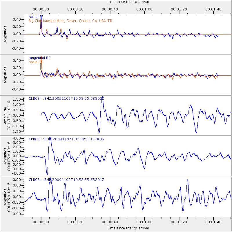
BC3 Big Chuckawalla Mtns, Desert Center, CA, USA - Earthquake Result Viewer
| Earthquake location: |
South Of Tonga Islands |
| Earthquake latitude/longitude: |
-24.1/-175.2 |
| Earthquake time(UTC): |
2009/11/02 (306) 10:47:13 GMT |
| Earthquake Depth: |
9.0 km |
| Earthquake Magnitude: |
6.1 MB, 6.1 MS, 6.2 MW, 6.1 MW |
| Earthquake Catalog/Contributor: |
WHDF/NEIC |
|
| Network: |
CI Caltech Regional Seismic Network |
| Station: |
BC3 Big Chuckawalla Mtns, Desert Center, CA, USA |
| Lat/Lon: |
33.66 N/115.45 W |
| Elevation: |
1137 m |
|
| Distance: |
80.8 deg |
| Az: |
46.862 deg |
| Baz: |
233.069 deg |
| Ray Param: |
0.048042342 |
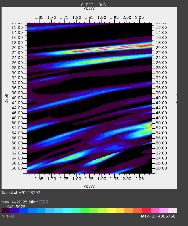
| Estimated Moho Depth: |
20.25 km |
| Estimated Crust Vp/Vs: |
1.90 |
| Assumed Crust Vp: |
6.155 km/s |
| Estimated Crust Vs: |
3.235 km/s |
| Estimated Crust Poisson's Ratio: |
0.31 |
|
| Radial Match: |
92.13792 % |
| Radial Bump: |
312 |
| Transverse Match: |
67.78433 % |
| Transverse Bump: |
400 |
| SOD ConfigId: |
2622 |
| Insert Time: |
2010-03-05 21:23:30.049 +0000 |
| GWidth: |
2.5 |
| Max Bumps: |
400 |
| Tol: |
0.001 |
|
Signal To Noise
| Channel | StoN | STA | LTA |
| CI:BC3: :BHN:20091102T10:58:55.63801Z | 22.925388 | 1.8495018E-6 | 8.067482E-8 |
| CI:BC3: :BHE:20091102T10:58:55.63801Z | 2.2596352 | 3.4431662E-7 | 1.5237707E-7 |
| CI:BC3: :BHZ:20091102T10:58:55.63801Z | 3.2303736 | 6.913059E-7 | 2.1400186E-7 |
| Arrivals |
| Ps | 3.0 SECOND |
| PpPs | 9.3 SECOND |
| PsPs/PpSs | 12 SECOND |


