You are here: Home > Network List > TA - USArray Transportable Network (new EarthScope stations) Stations List
> Station I23K Minto, Yukon-Koyukuk, AK, USA > Earthquake Result Viewer
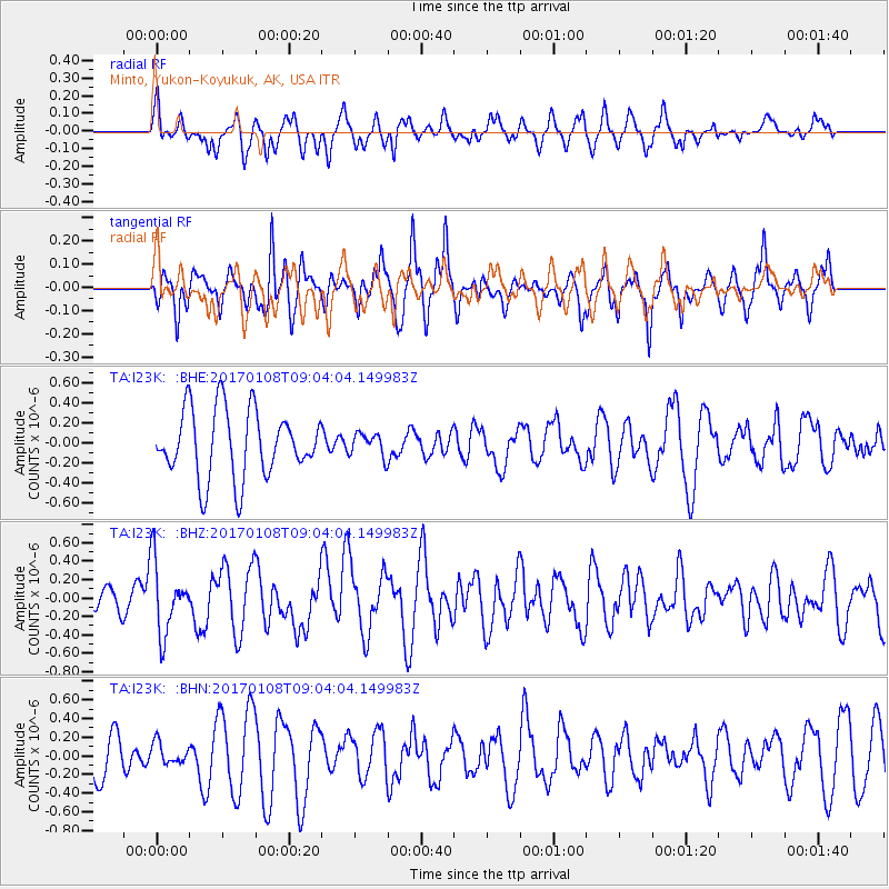
I23K Minto, Yukon-Koyukuk, AK, USA - Earthquake Result Viewer
*The percent match for this event was below the threshold and hence no stack was calculated.
| Earthquake location: |
Eastern New Guinea Reg., P.N.G. |
| Earthquake latitude/longitude: |
-6.2/147.5 |
| Earthquake time(UTC): |
2017/01/08 (008) 08:52:08 GMT |
| Earthquake Depth: |
67 km |
| Earthquake Magnitude: |
5.9 Mww |
| Earthquake Catalog/Contributor: |
NEIC PDE/us |
|
| Network: |
TA USArray Transportable Network (new EarthScope stations) |
| Station: |
I23K Minto, Yukon-Koyukuk, AK, USA |
| Lat/Lon: |
65.15 N/149.36 W |
| Elevation: |
149 m |
|
| Distance: |
84.7 deg |
| Az: |
22.252 deg |
| Baz: |
242.977 deg |
| Ray Param: |
$rayparam |
*The percent match for this event was below the threshold and hence was not used in the summary stack. |
|
| Radial Match: |
42.79127 % |
| Radial Bump: |
400 |
| Transverse Match: |
64.40667 % |
| Transverse Bump: |
400 |
| SOD ConfigId: |
11737051 |
| Insert Time: |
2019-04-26 13:57:37.181 +0000 |
| GWidth: |
2.5 |
| Max Bumps: |
400 |
| Tol: |
0.001 |
|
Signal To Noise
| Channel | StoN | STA | LTA |
| TA:I23K: :BHZ:20170108T09:04:04.149983Z | 2.2504904 | 3.814672E-7 | 1.6950403E-7 |
| TA:I23K: :BHN:20170108T09:04:04.149983Z | 0.4285791 | 1.12016E-7 | 2.6136598E-7 |
| TA:I23K: :BHE:20170108T09:04:04.149983Z | 0.35653862 | 1.2000592E-7 | 3.3658606E-7 |
| Arrivals |
| Ps | |
| PpPs | |
| PsPs/PpSs | |


