You are here: Home > Network List > UW - Pacific Northwest Regional Seismic Network Stations List
> Station LEBA Lebam, WA, USA > Earthquake Result Viewer
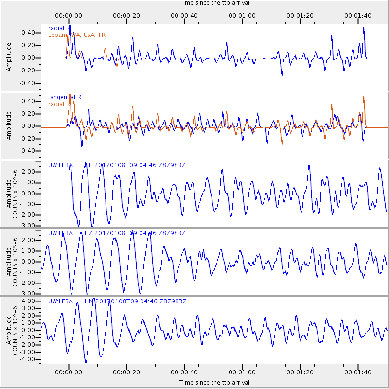
LEBA Lebam, WA, USA - Earthquake Result Viewer
*The percent match for this event was below the threshold and hence no stack was calculated.
| Earthquake location: |
Eastern New Guinea Reg., P.N.G. |
| Earthquake latitude/longitude: |
-6.2/147.5 |
| Earthquake time(UTC): |
2017/01/08 (008) 08:52:08 GMT |
| Earthquake Depth: |
67 km |
| Earthquake Magnitude: |
5.9 Mww |
| Earthquake Catalog/Contributor: |
NEIC PDE/us |
|
| Network: |
UW Pacific Northwest Regional Seismic Network |
| Station: |
LEBA Lebam, WA, USA |
| Lat/Lon: |
46.55 N/123.56 W |
| Elevation: |
73 m |
|
| Distance: |
93.8 deg |
| Az: |
43.755 deg |
| Baz: |
264.963 deg |
| Ray Param: |
$rayparam |
*The percent match for this event was below the threshold and hence was not used in the summary stack. |
|
| Radial Match: |
54.6809 % |
| Radial Bump: |
400 |
| Transverse Match: |
48.565636 % |
| Transverse Bump: |
400 |
| SOD ConfigId: |
11737051 |
| Insert Time: |
2019-04-26 13:58:26.181 +0000 |
| GWidth: |
2.5 |
| Max Bumps: |
400 |
| Tol: |
0.001 |
|
Signal To Noise
| Channel | StoN | STA | LTA |
| UW:LEBA: :HHZ:20170108T09:04:46.787983Z | 1.8599429 | 1.8796133E-6 | 1.0105758E-6 |
| UW:LEBA: :HHN:20170108T09:04:46.787983Z | 2.8434076 | 2.2463475E-6 | 7.9001956E-7 |
| UW:LEBA: :HHE:20170108T09:04:46.787983Z | 0.24001312 | 4.2736906E-7 | 1.7806071E-6 |
| Arrivals |
| Ps | |
| PpPs | |
| PsPs/PpSs | |


