You are here: Home > Network List > NN - Western Great Basin/Eastern Sierra Nevada Stations List
> Station OUT1 Outlaw Springs Mine, Nye County, NV, USA > Earthquake Result Viewer
OUT1 Outlaw Springs Mine, Nye County, NV, USA - Earthquake Result Viewer
| Earthquake location: |
Queen Elizabeth Islands, Canada |
| Earthquake latitude/longitude: |
74.3/-92.3 |
| Earthquake time(UTC): |
2017/01/08 (008) 23:47:12 GMT |
| Earthquake Depth: |
19 km |
| Earthquake Magnitude: |
5.8 Mwp |
| Earthquake Catalog/Contributor: |
NEIC PDE/us |
|
| Network: |
NN Western Great Basin/Eastern Sierra Nevada |
| Station: |
OUT1 Outlaw Springs Mine, Nye County, NV, USA |
| Lat/Lon: |
38.33 N/117.52 W |
| Elevation: |
1652 m |
|
| Distance: |
38.0 deg |
| Az: |
212.951 deg |
| Baz: |
10.84 deg |
| Ray Param: |
0.07578181 |
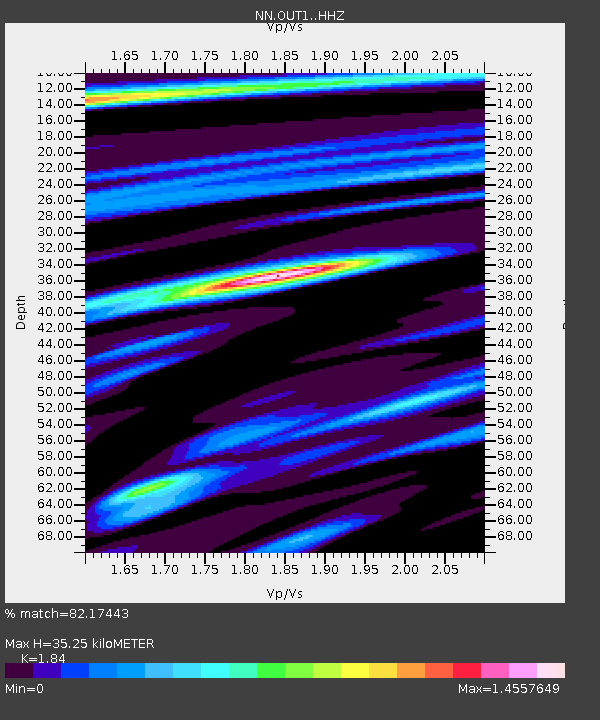
| Estimated Moho Depth: |
35.25 km |
| Estimated Crust Vp/Vs: |
1.84 |
| Assumed Crust Vp: |
6.276 km/s |
| Estimated Crust Vs: |
3.411 km/s |
| Estimated Crust Poisson's Ratio: |
0.29 |
|
| Radial Match: |
82.17443 % |
| Radial Bump: |
400 |
| Transverse Match: |
61.46245 % |
| Transverse Bump: |
400 |
| SOD ConfigId: |
11737051 |
| Insert Time: |
2019-04-26 14:11:37.265 +0000 |
| GWidth: |
2.5 |
| Max Bumps: |
400 |
| Tol: |
0.001 |
|

Signal To Noise
| Channel | StoN | STA | LTA |
| NN:OUT1: :HHZ:20170108T23:53:59.565004Z | 1.2853017 | 2.2395886E-7 | 1.7424614E-7 |
| NN:OUT1: :HHN:20170108T23:53:59.565004Z | 0.91584957 | 1.5854738E-7 | 1.731151E-7 |
| NN:OUT1: :HHE:20170108T23:53:59.565004Z | 1.0921373 | 2.3127402E-7 | 2.1176275E-7 |
| Arrivals |
| Ps | 5.0 SECOND |
| PpPs | 15 SECOND |
| PsPs/PpSs | 20 SECOND |


