You are here: Home > Network List > SN - Southern Great Basin Network Stations List
> Station HEL Hell's Gate, California w84 > Earthquake Result Viewer
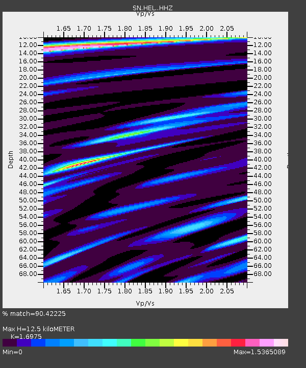
HEL Hell's Gate, California w84 - Earthquake Result Viewer
| Earthquake location: |
Queen Elizabeth Islands, Canada |
| Earthquake latitude/longitude: |
74.3/-92.3 |
| Earthquake time(UTC): |
2017/01/08 (008) 23:47:12 GMT |
| Earthquake Depth: |
19 km |
| Earthquake Magnitude: |
5.8 Mwp |
| Earthquake Catalog/Contributor: |
NEIC PDE/us |
|
| Network: |
SN Southern Great Basin Network |
| Station: |
HEL Hell's Gate, California w84 |
| Lat/Lon: |
36.72 N/116.98 W |
| Elevation: |
747 m |
|
| Distance: |
39.5 deg |
| Az: |
211.809 deg |
| Baz: |
10.277 deg |
| Ray Param: |
0.074919336 |
| Estimated Moho Depth: |
12.5 km |
| Estimated Crust Vp/Vs: |
1.70 |
| Assumed Crust Vp: |
6.279 km/s |
| Estimated Crust Vs: |
3.699 km/s |
| Estimated Crust Poisson's Ratio: |
0.23 |
|
| Radial Match: |
90.42225 % |
| Radial Bump: |
400 |
| Transverse Match: |
66.30541 % |
| Transverse Bump: |
400 |
| SOD ConfigId: |
11737051 |
| Insert Time: |
2019-04-26 14:13:11.938 +0000 |
| GWidth: |
2.5 |
| Max Bumps: |
400 |
| Tol: |
0.001 |
|

Signal To Noise
| Channel | StoN | STA | LTA |
| SN:HEL: :HHZ:20170108T23:54:12.067994Z | 2.792171 | 3.9761778E-7 | 1.4240452E-7 |
| SN:HEL: :HHN:20170108T23:54:12.067994Z | 4.4337373 | 3.2987066E-7 | 7.4400134E-8 |
| SN:HEL: :HHE:20170108T23:54:12.067994Z | 0.9461095 | 1.13943216E-7 | 1.2043344E-7 |
| Arrivals |
| Ps | 1.5 SECOND |
| PpPs | 5.0 SECOND |
| PsPs/PpSs | 6.5 SECOND |


