You are here: Home > Network List > US - United States National Seismic Network Stations List
> Station MNTX Cornudas Mountains, Texas, USA > Earthquake Result Viewer
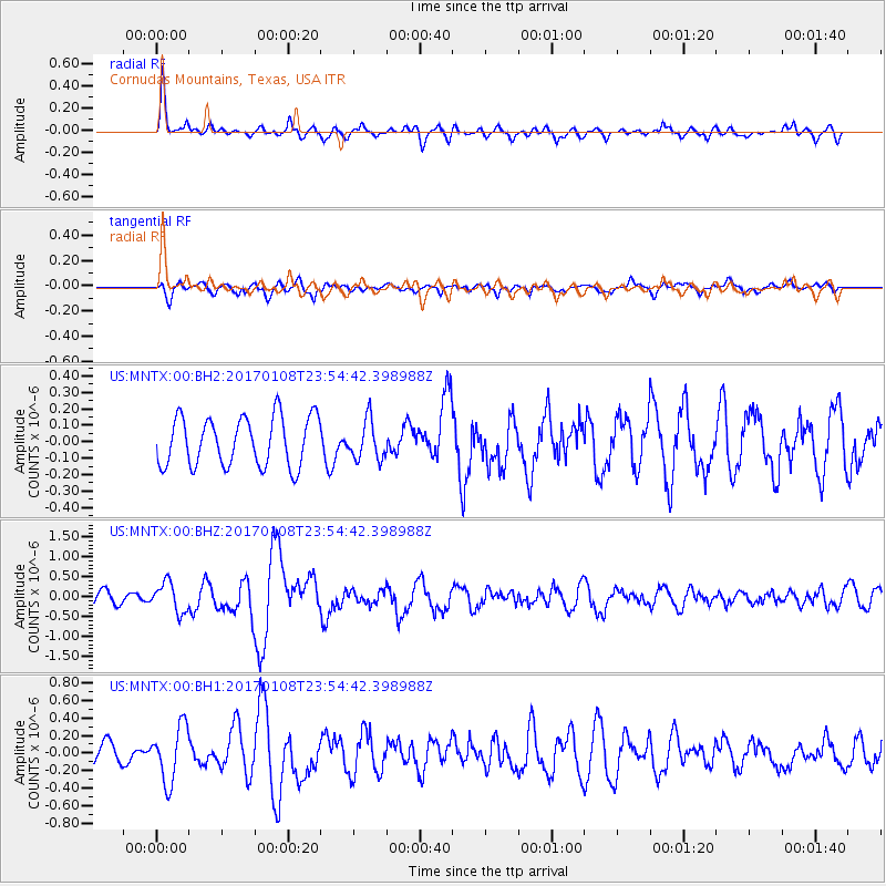
MNTX Cornudas Mountains, Texas, USA - Earthquake Result Viewer
*The percent match for this event was below the threshold and hence no stack was calculated.
| Earthquake location: |
Queen Elizabeth Islands, Canada |
| Earthquake latitude/longitude: |
74.3/-92.3 |
| Earthquake time(UTC): |
2017/01/08 (008) 23:47:12 GMT |
| Earthquake Depth: |
19 km |
| Earthquake Magnitude: |
5.8 Mwp |
| Earthquake Catalog/Contributor: |
NEIC PDE/us |
|
| Network: |
US United States National Seismic Network |
| Station: |
MNTX Cornudas Mountains, Texas, USA |
| Lat/Lon: |
31.70 N/105.38 W |
| Elevation: |
404 m |
|
| Distance: |
43.2 deg |
| Az: |
196.364 deg |
| Baz: |
5.157 deg |
| Ray Param: |
$rayparam |
*The percent match for this event was below the threshold and hence was not used in the summary stack. |
|
| Radial Match: |
78.34686 % |
| Radial Bump: |
360 |
| Transverse Match: |
54.053387 % |
| Transverse Bump: |
400 |
| SOD ConfigId: |
11737051 |
| Insert Time: |
2019-04-26 14:14:30.824 +0000 |
| GWidth: |
2.5 |
| Max Bumps: |
400 |
| Tol: |
0.001 |
|
Signal To Noise
| Channel | StoN | STA | LTA |
| US:MNTX:00:BHZ:20170108T23:54:42.398988Z | 1.6556895 | 3.6808922E-7 | 2.2231777E-7 |
| US:MNTX:00:BH1:20170108T23:54:42.398988Z | 1.7001381 | 3.152705E-7 | 1.8543817E-7 |
| US:MNTX:00:BH2:20170108T23:54:42.398988Z | 0.7634244 | 1.12285356E-7 | 1.4708118E-7 |
| Arrivals |
| Ps | |
| PpPs | |
| PsPs/PpSs | |


