You are here: Home > Network List > AK - Alaska Regional Network Stations List
> Station SII Sitkinak Island Coast Guard > Earthquake Result Viewer
SII Sitkinak Island Coast Guard - Earthquake Result Viewer
| Earthquake location: |
Celebes Sea |
| Earthquake latitude/longitude: |
4.4/122.7 |
| Earthquake time(UTC): |
2017/01/10 (010) 06:13:48 GMT |
| Earthquake Depth: |
622 km |
| Earthquake Magnitude: |
6.9 Mi |
| Earthquake Catalog/Contributor: |
NEIC PDE/at |
|
| Network: |
AK Alaska Regional Network |
| Station: |
SII Sitkinak Island Coast Guard |
| Lat/Lon: |
56.56 N/154.18 W |
| Elevation: |
465 m |
|
| Distance: |
82.5 deg |
| Az: |
33.666 deg |
| Baz: |
266.689 deg |
| Ray Param: |
0.044929557 |
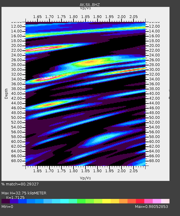
| Estimated Moho Depth: |
32.75 km |
| Estimated Crust Vp/Vs: |
1.71 |
| Assumed Crust Vp: |
6.24 km/s |
| Estimated Crust Vs: |
3.644 km/s |
| Estimated Crust Poisson's Ratio: |
0.24 |
|
| Radial Match: |
80.29327 % |
| Radial Bump: |
400 |
| Transverse Match: |
74.55026 % |
| Transverse Bump: |
400 |
| SOD ConfigId: |
11737051 |
| Insert Time: |
2019-04-26 14:21:26.518 +0000 |
| GWidth: |
2.5 |
| Max Bumps: |
400 |
| Tol: |
0.001 |
|

Signal To Noise
| Channel | StoN | STA | LTA |
| AK:SII: :BHZ:20170110T06:24:36.187988Z | 5.476631 | 5.835735E-6 | 1.0655702E-6 |
| AK:SII: :BHN:20170110T06:24:36.187988Z | 0.97809327 | 2.341787E-6 | 2.3942368E-6 |
| AK:SII: :BHE:20170110T06:24:36.187988Z | 2.0591643 | 2.210691E-6 | 1.0735864E-6 |
| Arrivals |
| Ps | 3.8 SECOND |
| PpPs | 14 SECOND |
| PsPs/PpSs | 18 SECOND |


