You are here: Home > Network List > AV - Alaska Volcano Observatory Stations List
> Station SPCR Ckakachatna River, Mount Spurr, Alaska > Earthquake Result Viewer
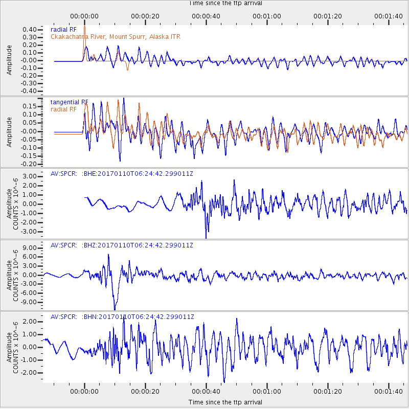
SPCR Ckakachatna River, Mount Spurr, Alaska - Earthquake Result Viewer
*The percent match for this event was below the threshold and hence no stack was calculated.
| Earthquake location: |
Celebes Sea |
| Earthquake latitude/longitude: |
4.4/122.7 |
| Earthquake time(UTC): |
2017/01/10 (010) 06:13:48 GMT |
| Earthquake Depth: |
622 km |
| Earthquake Magnitude: |
6.9 Mi |
| Earthquake Catalog/Contributor: |
NEIC PDE/at |
|
| Network: |
AV Alaska Volcano Observatory |
| Station: |
SPCR Ckakachatna River, Mount Spurr, Alaska |
| Lat/Lon: |
61.20 N/152.21 W |
| Elevation: |
984 m |
|
| Distance: |
83.8 deg |
| Az: |
29.033 deg |
| Baz: |
267.825 deg |
| Ray Param: |
$rayparam |
*The percent match for this event was below the threshold and hence was not used in the summary stack. |
|
| Radial Match: |
74.08043 % |
| Radial Bump: |
400 |
| Transverse Match: |
79.11966 % |
| Transverse Bump: |
400 |
| SOD ConfigId: |
11737051 |
| Insert Time: |
2019-04-26 14:22:23.524 +0000 |
| GWidth: |
2.5 |
| Max Bumps: |
400 |
| Tol: |
0.001 |
|
Signal To Noise
| Channel | StoN | STA | LTA |
| AV:SPCR: :BHZ:20170110T06:24:42.299011Z | 1.9319291 | 1.0587544E-6 | 5.480296E-7 |
| AV:SPCR: :BHN:20170110T06:24:42.299011Z | 1.268256 | 4.0331065E-7 | 3.1800414E-7 |
| AV:SPCR: :BHE:20170110T06:24:42.299011Z | 1.8101786 | 6.8329115E-7 | 3.7747165E-7 |
| Arrivals |
| Ps | |
| PpPs | |
| PsPs/PpSs | |


