You are here: Home > Network List > JP - Japan Meteorological Agency Seismic Network Stations List
> Station JHS Hiroshima Saijyo > Earthquake Result Viewer
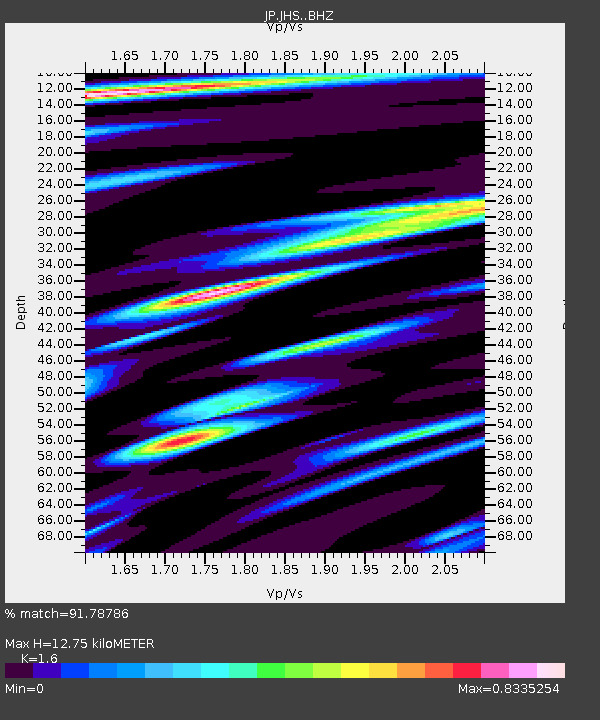
JHS Hiroshima Saijyo - Earthquake Result Viewer
| Earthquake location: |
Celebes Sea |
| Earthquake latitude/longitude: |
4.4/122.7 |
| Earthquake time(UTC): |
2017/01/10 (010) 06:13:48 GMT |
| Earthquake Depth: |
622 km |
| Earthquake Magnitude: |
6.9 Mi |
| Earthquake Catalog/Contributor: |
NEIC PDE/at |
|
| Network: |
JP Japan Meteorological Agency Seismic Network |
| Station: |
JHS Hiroshima Saijyo |
| Lat/Lon: |
35.00 N/133.11 E |
| Elevation: |
470 m |
|
| Distance: |
31.9 deg |
| Az: |
16.283 deg |
| Baz: |
199.91 deg |
| Ray Param: |
0.07583885 |
| Estimated Moho Depth: |
12.75 km |
| Estimated Crust Vp/Vs: |
1.60 |
| Assumed Crust Vp: |
6.468 km/s |
| Estimated Crust Vs: |
4.042 km/s |
| Estimated Crust Poisson's Ratio: |
0.18 |
|
| Radial Match: |
91.78786 % |
| Radial Bump: |
359 |
| Transverse Match: |
84.67331 % |
| Transverse Bump: |
400 |
| SOD ConfigId: |
11737051 |
| Insert Time: |
2019-04-26 14:23:44.983 +0000 |
| GWidth: |
2.5 |
| Max Bumps: |
400 |
| Tol: |
0.001 |
|

Signal To Noise
| Channel | StoN | STA | LTA |
| JP:JHS: :BHZ:20170110T06:18:54.200012Z | 4.1556334 | 2.7337621E-6 | 6.5784485E-7 |
| JP:JHS: :BHN:20170110T06:18:54.200012Z | 1.7445117 | 1.2271158E-6 | 7.034151E-7 |
| JP:JHS: :BHE:20170110T06:18:54.200012Z | 1.0211596 | 6.3856737E-7 | 6.253355E-7 |
| Arrivals |
| Ps | 1.3 SECOND |
| PpPs | 4.7 SECOND |
| PsPs/PpSs | 6.0 SECOND |


