You are here: Home > Network List > TA - USArray Transportable Network (new EarthScope stations) Stations List
> Station G21K Allakaket, AK, USA > Earthquake Result Viewer
G21K Allakaket, AK, USA - Earthquake Result Viewer
| Earthquake location: |
Celebes Sea |
| Earthquake latitude/longitude: |
4.4/122.7 |
| Earthquake time(UTC): |
2017/01/10 (010) 06:13:48 GMT |
| Earthquake Depth: |
622 km |
| Earthquake Magnitude: |
6.9 Mi |
| Earthquake Catalog/Contributor: |
NEIC PDE/at |
|
| Network: |
TA USArray Transportable Network (new EarthScope stations) |
| Station: |
G21K Allakaket, AK, USA |
| Lat/Lon: |
66.52 N/153.51 W |
| Elevation: |
446 m |
|
| Distance: |
83.5 deg |
| Az: |
23.64 deg |
| Baz: |
266.063 deg |
| Ray Param: |
0.044278063 |
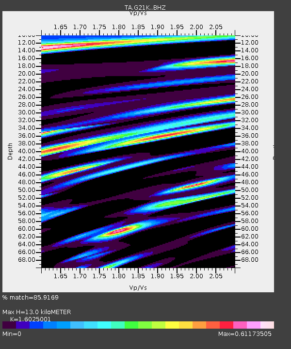
| Estimated Moho Depth: |
13.0 km |
| Estimated Crust Vp/Vs: |
1.60 |
| Assumed Crust Vp: |
6.455 km/s |
| Estimated Crust Vs: |
4.028 km/s |
| Estimated Crust Poisson's Ratio: |
0.18 |
|
| Radial Match: |
85.9169 % |
| Radial Bump: |
396 |
| Transverse Match: |
87.963234 % |
| Transverse Bump: |
400 |
| SOD ConfigId: |
11737051 |
| Insert Time: |
2019-04-26 14:25:37.815 +0000 |
| GWidth: |
2.5 |
| Max Bumps: |
400 |
| Tol: |
0.001 |
|
Signal To Noise
| Channel | StoN | STA | LTA |
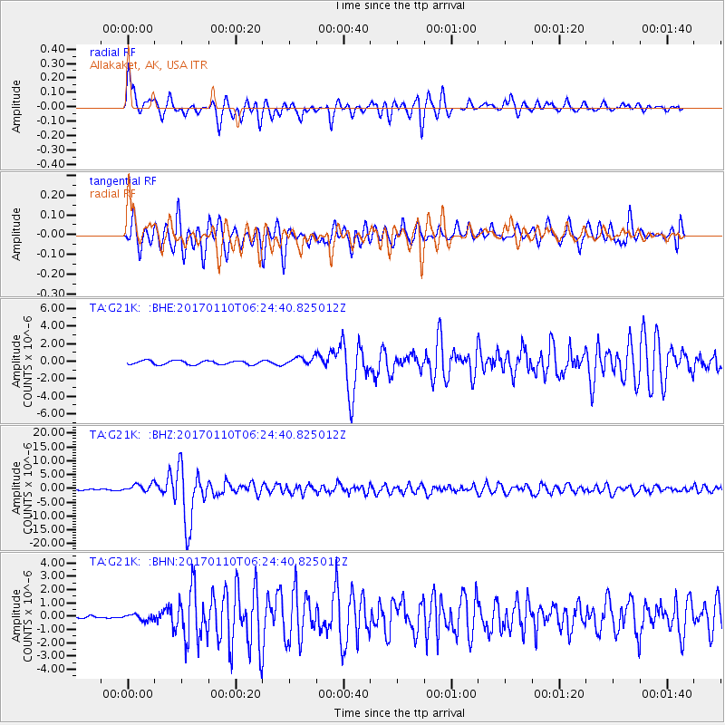
| TA:G21K: :BHZ:20170110T06:24:40.825012Z | 11.391226 | 1.5692974E-6 | 1.3776369E-7 |
| TA:G21K: :BHN:20170110T06:24:40.825012Z | 1.7687151 | 2.1555867E-7 | 1.2187303E-7 |
| TA:G21K: :BHE:20170110T06:24:40.825012Z | 2.1477854 | 4.787642E-7 | 2.2291064E-7 |
| Arrivals |
| Ps | 1.2 SECOND |
| PpPs | 5.1 SECOND |
| PsPs/PpSs | 6.4 SECOND |


