You are here: Home > Network List > TA - USArray Transportable Network (new EarthScope stations) Stations List
> Station G23K Bananza Creek, AK, USA > Earthquake Result Viewer
G23K Bananza Creek, AK, USA - Earthquake Result Viewer

| Earthquake location: |
Celebes Sea |
| Earthquake latitude/longitude: |
4.4/122.7 |
| Earthquake time(UTC): |
2017/01/10 (010) 06:13:48 GMT |
| Earthquake Depth: |
622 km |
| Earthquake Magnitude: |
6.9 Mi |
| Earthquake Catalog/Contributor: |
NEIC PDE/at |
|
| Network: |
TA USArray Transportable Network (new EarthScope stations) |
| Station: |
G23K Bananza Creek, AK, USA |
| Lat/Lon: |
66.71 N/150.02 W |
| Elevation: |
746 m |
|
| Distance: |
84.9 deg |
| Az: |
23.5 deg |
| Baz: |
269.241 deg |
| Ray Param: |
0.04331918 |
| Estimated Moho Depth: |
41.75 km |
| Estimated Crust Vp/Vs: |
1.61 |
| Assumed Crust Vp: |
6.577 km/s |
| Estimated Crust Vs: |
4.091 km/s |
| Estimated Crust Poisson's Ratio: |
0.18 |
|
| Radial Match: |
90.28071 % |
| Radial Bump: |
400 |
| Transverse Match: |
82.24955 % |
| Transverse Bump: |
400 |
| SOD ConfigId: |
11737051 |
| Insert Time: |
2019-04-26 14:25:40.586 +0000 |
| GWidth: |
2.5 |
| Max Bumps: |
400 |
| Tol: |
0.001 |
|
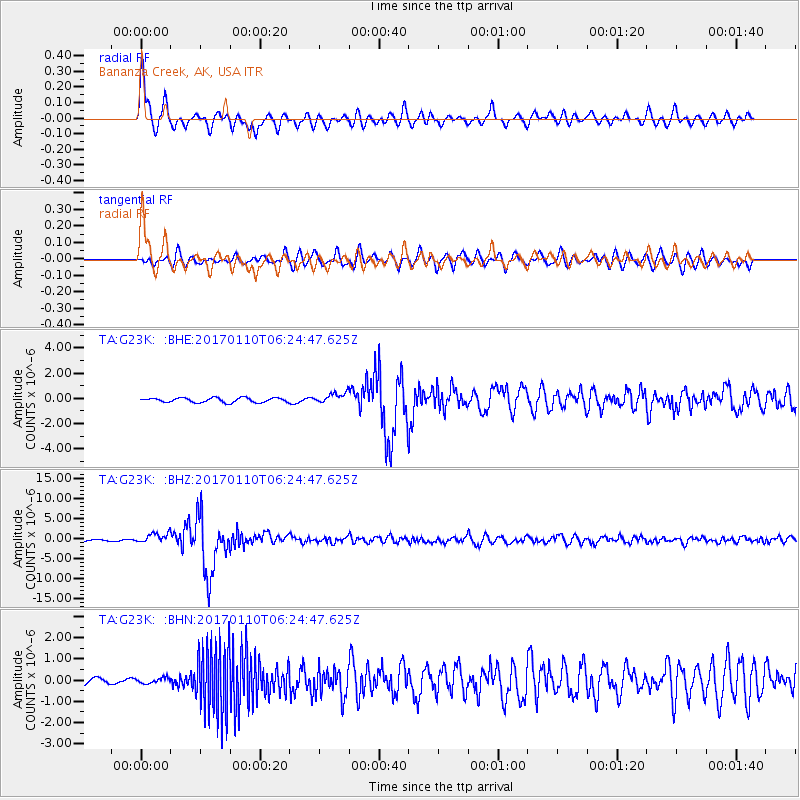
Signal To Noise
| Channel | StoN | STA | LTA |
| TA:G23K: :BHZ:20170110T06:24:47.625Z | 6.969682 | 1.2868597E-6 | 1.8463679E-7 |
| TA:G23K: :BHN:20170110T06:24:47.625Z | 0.86017114 | 1.2717692E-7 | 1.4785071E-7 |
| TA:G23K: :BHE:20170110T06:24:47.625Z | 2.2217667 | 3.9525952E-7 | 1.7790325E-7 |
| Arrivals |
| Ps | 4.0 SECOND |
| PpPs | 16 SECOND |
| PsPs/PpSs | 20 SECOND |


