You are here: Home > Network List > TA - USArray Transportable Network (new EarthScope stations) Stations List
> Station G26K Porcupine River, AK, USA > Earthquake Result Viewer
G26K Porcupine River, AK, USA - Earthquake Result Viewer
| Earthquake location: |
Celebes Sea |
| Earthquake latitude/longitude: |
4.4/122.7 |
| Earthquake time(UTC): |
2017/01/10 (010) 06:13:48 GMT |
| Earthquake Depth: |
622 km |
| Earthquake Magnitude: |
6.9 Mi |
| Earthquake Catalog/Contributor: |
NEIC PDE/at |
|
| Network: |
TA USArray Transportable Network (new EarthScope stations) |
| Station: |
G26K Porcupine River, AK, USA |
| Lat/Lon: |
66.95 N/143.78 W |
| Elevation: |
180 m |
|
| Distance: |
87.3 deg |
| Az: |
23.17 deg |
| Baz: |
274.95 deg |
| Ray Param: |
0.0417195 |
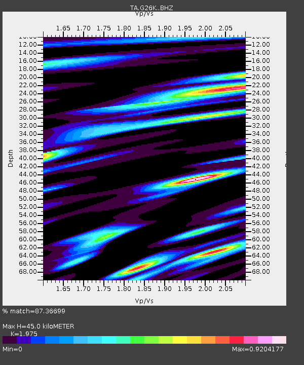
| Estimated Moho Depth: |
45.0 km |
| Estimated Crust Vp/Vs: |
1.98 |
| Assumed Crust Vp: |
6.577 km/s |
| Estimated Crust Vs: |
3.33 km/s |
| Estimated Crust Poisson's Ratio: |
0.33 |
|
| Radial Match: |
87.36699 % |
| Radial Bump: |
400 |
| Transverse Match: |
84.95248 % |
| Transverse Bump: |
400 |
| SOD ConfigId: |
11737051 |
| Insert Time: |
2019-04-26 14:25:41.392 +0000 |
| GWidth: |
2.5 |
| Max Bumps: |
400 |
| Tol: |
0.001 |
|

Signal To Noise
| Channel | StoN | STA | LTA |
| TA:G26K: :BHZ:20170110T06:24:59.200012Z | 6.881796 | 9.0367485E-7 | 1.3131381E-7 |
| TA:G26K: :BHN:20170110T06:24:59.200012Z | 0.9620756 | 1.3281725E-7 | 1.3805283E-7 |
| TA:G26K: :BHE:20170110T06:24:59.200012Z | 2.4477553 | 4.171993E-7 | 1.704416E-7 |
| Arrivals |
| Ps | 6.8 SECOND |
| PpPs | 20 SECOND |
| PsPs/PpSs | 27 SECOND |


