You are here: Home > Network List > TA - USArray Transportable Network (new EarthScope stations) Stations List
> Station I21K Tanana, AK, USA > Earthquake Result Viewer
I21K Tanana, AK, USA - Earthquake Result Viewer
| Earthquake location: |
Celebes Sea |
| Earthquake latitude/longitude: |
4.4/122.7 |
| Earthquake time(UTC): |
2017/01/10 (010) 06:13:48 GMT |
| Earthquake Depth: |
622 km |
| Earthquake Magnitude: |
6.9 Mi |
| Earthquake Catalog/Contributor: |
NEIC PDE/at |
|
| Network: |
TA USArray Transportable Network (new EarthScope stations) |
| Station: |
I21K Tanana, AK, USA |
| Lat/Lon: |
65.18 N/151.98 W |
| Elevation: |
248 m |
|
| Distance: |
84.0 deg |
| Az: |
25.022 deg |
| Baz: |
267.602 deg |
| Ray Param: |
0.04390217 |
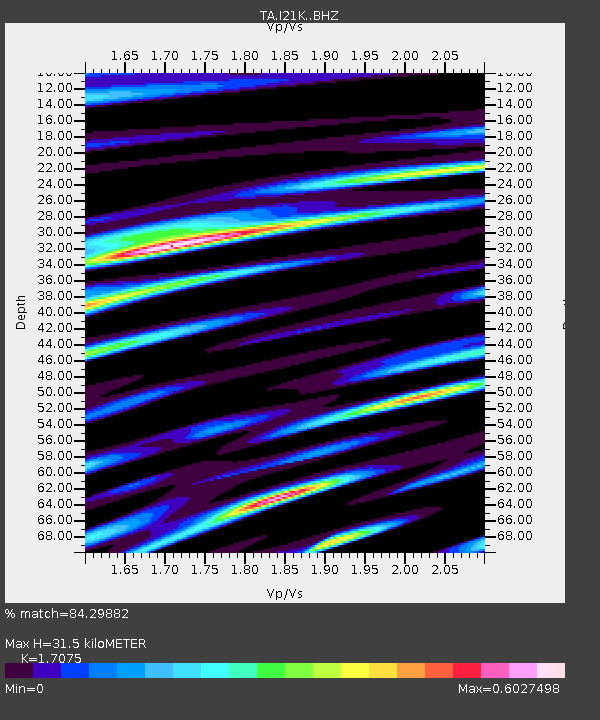
| Estimated Moho Depth: |
31.5 km |
| Estimated Crust Vp/Vs: |
1.71 |
| Assumed Crust Vp: |
6.566 km/s |
| Estimated Crust Vs: |
3.845 km/s |
| Estimated Crust Poisson's Ratio: |
0.24 |
|
| Radial Match: |
84.29882 % |
| Radial Bump: |
389 |
| Transverse Match: |
91.29009 % |
| Transverse Bump: |
332 |
| SOD ConfigId: |
11737051 |
| Insert Time: |
2019-04-26 14:25:49.427 +0000 |
| GWidth: |
2.5 |
| Max Bumps: |
400 |
| Tol: |
0.001 |
|

Signal To Noise
| Channel | StoN | STA | LTA |
| TA:I21K: :BHZ:20170110T06:24:43.549988Z | 6.725325 | 1.497611E-6 | 2.2268233E-7 |
| TA:I21K: :BHN:20170110T06:24:43.549988Z | 1.4988714 | 2.6156906E-7 | 1.7451066E-7 |
| TA:I21K: :BHE:20170110T06:24:43.549988Z | 1.35671 | 5.0693086E-7 | 3.736472E-7 |
| Arrivals |
| Ps | 3.5 SECOND |
| PpPs | 13 SECOND |
| PsPs/PpSs | 16 SECOND |


