You are here: Home > Network List > TA - USArray Transportable Network (new EarthScope stations) Stations List
> Station Q19K Cape Douglas, AK, USA > Earthquake Result Viewer
Q19K Cape Douglas, AK, USA - Earthquake Result Viewer
| Earthquake location: |
Celebes Sea |
| Earthquake latitude/longitude: |
4.4/122.7 |
| Earthquake time(UTC): |
2017/01/10 (010) 06:13:48 GMT |
| Earthquake Depth: |
622 km |
| Earthquake Magnitude: |
6.9 Mi |
| Earthquake Catalog/Contributor: |
NEIC PDE/at |
|
| Network: |
TA USArray Transportable Network (new EarthScope stations) |
| Station: |
Q19K Cape Douglas, AK, USA |
| Lat/Lon: |
58.93 N/153.64 W |
| Elevation: |
631 m |
|
| Distance: |
83.0 deg |
| Az: |
31.291 deg |
| Baz: |
266.844 deg |
| Ray Param: |
0.044641014 |
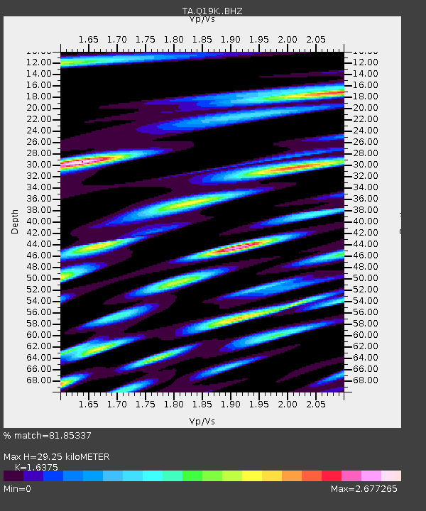
| Estimated Moho Depth: |
29.25 km |
| Estimated Crust Vp/Vs: |
1.64 |
| Assumed Crust Vp: |
5.989 km/s |
| Estimated Crust Vs: |
3.657 km/s |
| Estimated Crust Poisson's Ratio: |
0.20 |
|
| Radial Match: |
81.85337 % |
| Radial Bump: |
400 |
| Transverse Match: |
84.378 % |
| Transverse Bump: |
400 |
| SOD ConfigId: |
11737051 |
| Insert Time: |
2019-04-26 14:26:25.121 +0000 |
| GWidth: |
2.5 |
| Max Bumps: |
400 |
| Tol: |
0.001 |
|

Signal To Noise
| Channel | StoN | STA | LTA |
| TA:Q19K: :BHZ:20170110T06:24:38.275024Z | 5.26199 | 2.3469436E-6 | 4.4601822E-7 |
| TA:Q19K: :BHN:20170110T06:24:38.275024Z | 2.423038 | 1.2455096E-6 | 5.140281E-7 |
| TA:Q19K: :BHE:20170110T06:24:38.275024Z | 1.8630906 | 1.2899158E-6 | 6.9235267E-7 |
| Arrivals |
| Ps | 3.2 SECOND |
| PpPs | 13 SECOND |
| PsPs/PpSs | 16 SECOND |


