You are here: Home > Network List > TA - USArray Transportable Network (new EarthScope stations) Stations List
> Station R32K Eaglecrest, AK, USA > Earthquake Result Viewer
R32K Eaglecrest, AK, USA - Earthquake Result Viewer
*The percent match for this event was below the threshold and hence no stack was calculated.
| Earthquake location: |
Celebes Sea |
| Earthquake latitude/longitude: |
4.4/122.7 |
| Earthquake time(UTC): |
2017/01/10 (010) 06:13:48 GMT |
| Earthquake Depth: |
622 km |
| Earthquake Magnitude: |
6.9 Mi |
| Earthquake Catalog/Contributor: |
NEIC PDE/at |
|
| Network: |
TA USArray Transportable Network (new EarthScope stations) |
| Station: |
R32K Eaglecrest, AK, USA |
| Lat/Lon: |
58.27 N/134.52 W |
| Elevation: |
386 m |
|
| Distance: |
92.9 deg |
| Az: |
31.065 deg |
| Baz: |
283.173 deg |
| Ray Param: |
$rayparam |
*The percent match for this event was below the threshold and hence was not used in the summary stack. |
|
| Radial Match: |
66.48417 % |
| Radial Bump: |
400 |
| Transverse Match: |
67.90523 % |
| Transverse Bump: |
400 |
| SOD ConfigId: |
11737051 |
| Insert Time: |
2019-04-26 14:26:29.184 +0000 |
| GWidth: |
2.5 |
| Max Bumps: |
400 |
| Tol: |
0.001 |
|
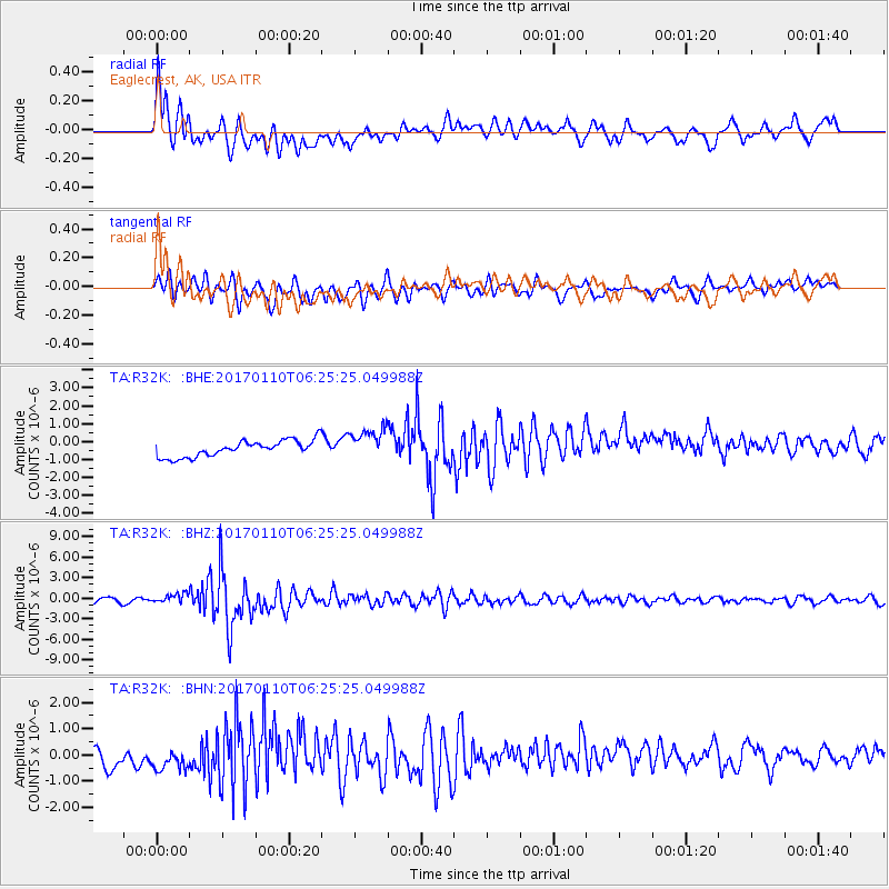
Signal To Noise
| Channel | StoN | STA | LTA |
| TA:R32K: :BHZ:20170110T06:25:25.049988Z | 2.316326 | 6.98231E-7 | 3.0143903E-7 |
| TA:R32K: :BHN:20170110T06:25:25.049988Z | 1.4433129 | 6.8035314E-7 | 4.7138295E-7 |
| TA:R32K: :BHE:20170110T06:25:25.049988Z | 1.9091911 | 8.47815E-7 | 4.4407025E-7 |
| Arrivals |
| Ps | |
| PpPs | |
| PsPs/PpSs | |


