You are here: Home > Network List > CI - Caltech Regional Seismic Network Stations List
> Station DAN DAN, Needles, CA, USA > Earthquake Result Viewer
DAN DAN, Needles, CA, USA - Earthquake Result Viewer
| Earthquake location: |
Jujuy Province, Argentina |
| Earthquake latitude/longitude: |
-23.5/-66.5 |
| Earthquake time(UTC): |
2000/05/12 (133) 18:43:18 GMT |
| Earthquake Depth: |
225 km |
| Earthquake Magnitude: |
6.2 MB, 7.2 MW, 7.1 MW |
| Earthquake Catalog/Contributor: |
WHDF/NEIC |
|
| Network: |
CI Caltech Regional Seismic Network |
| Station: |
DAN DAN, Needles, CA, USA |
| Lat/Lon: |
34.64 N/115.38 W |
| Elevation: |
428 m |
|
| Distance: |
74.2 deg |
| Az: |
319.756 deg |
| Baz: |
134.025 deg |
| Ray Param: |
0.051889032 |
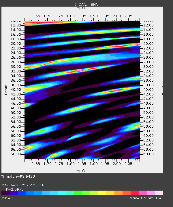
| Estimated Moho Depth: |
20.25 km |
| Estimated Crust Vp/Vs: |
2.10 |
| Assumed Crust Vp: |
6.276 km/s |
| Estimated Crust Vs: |
2.992 km/s |
| Estimated Crust Poisson's Ratio: |
0.35 |
|
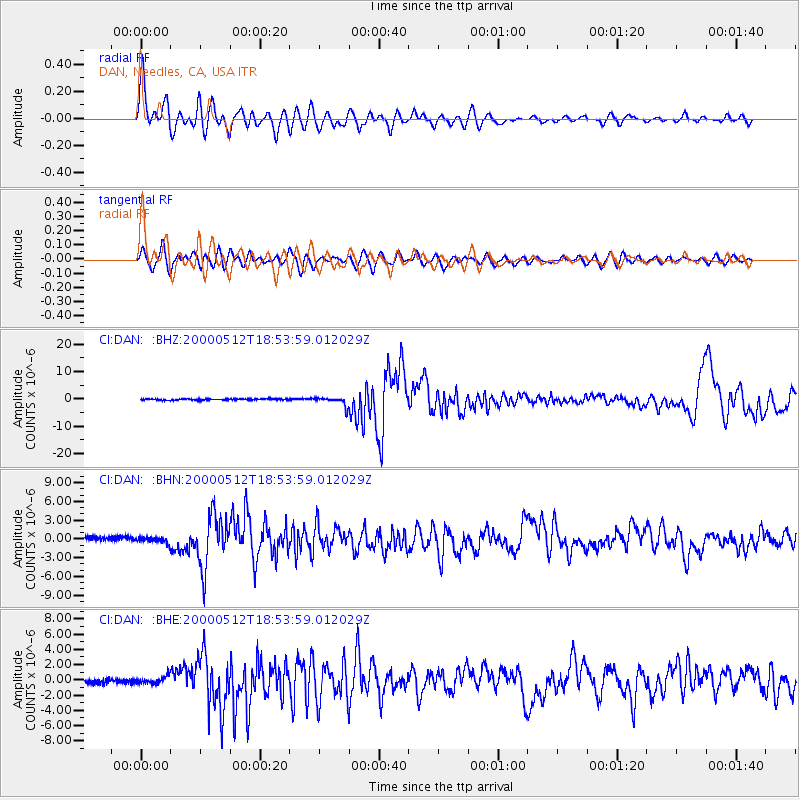
| Radial Match: |
93.9426 % |
| Radial Bump: |
400 |
| Transverse Match: |
83.21229 % |
| Transverse Bump: |
400 |
| SOD ConfigId: |
3787 |
| Insert Time: |
2010-02-26 01:00:08.451 +0000 |
| GWidth: |
2.5 |
| Max Bumps: |
400 |
| Tol: |
0.001 |
|
Signal To Noise
| Channel | StoN | STA | LTA |
| CI:DAN: :BHN:20000512T18:53:59.012029Z | 1.3503815 | 4.194406E-7 | 3.1060895E-7 |
| CI:DAN: :BHE:20000512T18:53:59.012029Z | 1.6571009 | 4.928095E-7 | 2.9739255E-7 |
| CI:DAN: :BHZ:20000512T18:53:59.012029Z | 6.601435 | 1.5972844E-6 | 2.4196018E-7 |
| Arrivals |
| Ps | 3.6 SECOND |
| PpPs | 9.7 SECOND |
| PsPs/PpSs | 13 SECOND |


