You are here: Home > Network List > CI - Caltech Regional Seismic Network Stations List
> Station MPP McPhearson Peak > Earthquake Result Viewer
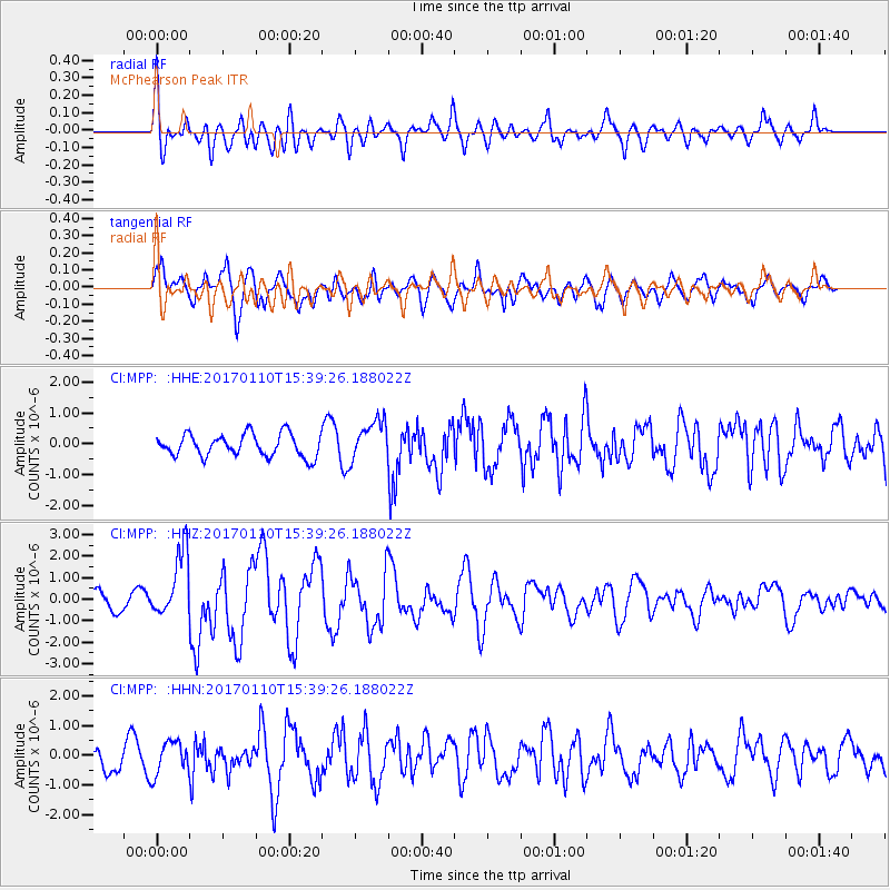
MPP McPhearson Peak - Earthquake Result Viewer
*The percent match for this event was below the threshold and hence no stack was calculated.
| Earthquake location: |
Solomon Islands |
| Earthquake latitude/longitude: |
-10.1/161.0 |
| Earthquake time(UTC): |
2017/01/10 (010) 15:27:15 GMT |
| Earthquake Depth: |
28 km |
| Earthquake Magnitude: |
6.3 Mww |
| Earthquake Catalog/Contributor: |
NEIC PDE/us |
|
| Network: |
CI Caltech Regional Seismic Network |
| Station: |
MPP McPhearson Peak |
| Lat/Lon: |
34.89 N/119.81 W |
| Elevation: |
1739 m |
|
| Distance: |
87.0 deg |
| Az: |
53.951 deg |
| Baz: |
255.553 deg |
| Ray Param: |
$rayparam |
*The percent match for this event was below the threshold and hence was not used in the summary stack. |
|
| Radial Match: |
64.45836 % |
| Radial Bump: |
400 |
| Transverse Match: |
74.77237 % |
| Transverse Bump: |
400 |
| SOD ConfigId: |
11737051 |
| Insert Time: |
2019-04-26 14:31:19.334 +0000 |
| GWidth: |
2.5 |
| Max Bumps: |
400 |
| Tol: |
0.001 |
|
Signal To Noise
| Channel | StoN | STA | LTA |
| CI:MPP: :HHZ:20170110T15:39:26.188022Z | 4.8771477 | 1.5380263E-6 | 3.1535362E-7 |
| CI:MPP: :HHN:20170110T15:39:26.188022Z | 1.6476982 | 5.5060474E-7 | 3.3416603E-7 |
| CI:MPP: :HHE:20170110T15:39:26.188022Z | 1.8020006 | 6.5192097E-7 | 3.6177622E-7 |
| Arrivals |
| Ps | |
| PpPs | |
| PsPs/PpSs | |


