You are here: Home > Network List > CI - Caltech Regional Seismic Network Stations List
> Station DGR Domenigoni Reservoir, California, USA > Earthquake Result Viewer
DGR Domenigoni Reservoir, California, USA - Earthquake Result Viewer
| Earthquake location: |
Loyalty Islands |
| Earthquake latitude/longitude: |
-20.1/168.9 |
| Earthquake time(UTC): |
2008/04/09 (100) 12:46:12 GMT |
| Earthquake Depth: |
33 km |
| Earthquake Magnitude: |
6.3 MB, 7.3 MS, 7.3 MW, 7.3 MW |
| Earthquake Catalog/Contributor: |
WHDF/NEIC |
|
| Network: |
CI Caltech Regional Seismic Network |
| Station: |
DGR Domenigoni Reservoir, California, USA |
| Lat/Lon: |
33.65 N/117.01 W |
| Elevation: |
609 m |
|
| Distance: |
88.5 deg |
| Az: |
53.371 deg |
| Baz: |
244.737 deg |
| Ray Param: |
0.042519305 |
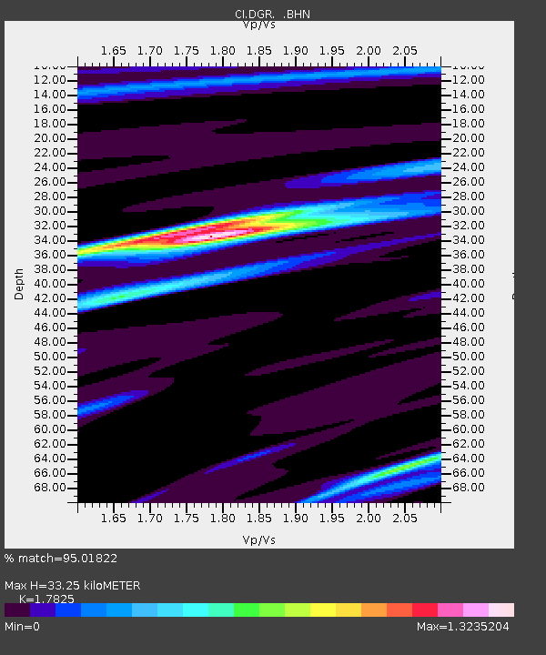
| Estimated Moho Depth: |
33.25 km |
| Estimated Crust Vp/Vs: |
1.78 |
| Assumed Crust Vp: |
6.264 km/s |
| Estimated Crust Vs: |
3.514 km/s |
| Estimated Crust Poisson's Ratio: |
0.27 |
|
| Radial Match: |
95.01822 % |
| Radial Bump: |
269 |
| Transverse Match: |
90.50784 % |
| Transverse Bump: |
396 |
| SOD ConfigId: |
2504 |
| Insert Time: |
2010-03-05 21:28:36.552 +0000 |
| GWidth: |
2.5 |
| Max Bumps: |
400 |
| Tol: |
0.001 |
|

Signal To Noise
| Channel | StoN | STA | LTA |
| CI:DGR: :BHN:20080409T12:58:30.448027Z | 7.5648146 | 2.1308974E-6 | 2.8168535E-7 |
| CI:DGR: :BHE:20080409T12:58:30.448027Z | 1.2828223 | 3.259949E-7 | 2.5412322E-7 |
| CI:DGR: :BHZ:20080409T12:58:30.448027Z | 3.477972 | 6.7176063E-7 | 1.9314722E-7 |
| Arrivals |
| Ps | 4.2 SECOND |
| PpPs | 14 SECOND |
| PsPs/PpSs | 19 SECOND |


