You are here: Home > Network List > TA - USArray Transportable Network (new EarthScope stations) Stations List
> Station M22K Willow, AK, USA > Earthquake Result Viewer
M22K Willow, AK, USA - Earthquake Result Viewer
| Earthquake location: |
Solomon Islands |
| Earthquake latitude/longitude: |
-10.1/161.0 |
| Earthquake time(UTC): |
2017/01/10 (010) 15:27:15 GMT |
| Earthquake Depth: |
28 km |
| Earthquake Magnitude: |
6.3 Mww |
| Earthquake Catalog/Contributor: |
NEIC PDE/us |
|
| Network: |
TA USArray Transportable Network (new EarthScope stations) |
| Station: |
M22K Willow, AK, USA |
| Lat/Lon: |
61.75 N/150.12 W |
| Elevation: |
57 m |
|
| Distance: |
81.1 deg |
| Az: |
21.259 deg |
| Baz: |
228.628 deg |
| Ray Param: |
0.047778837 |
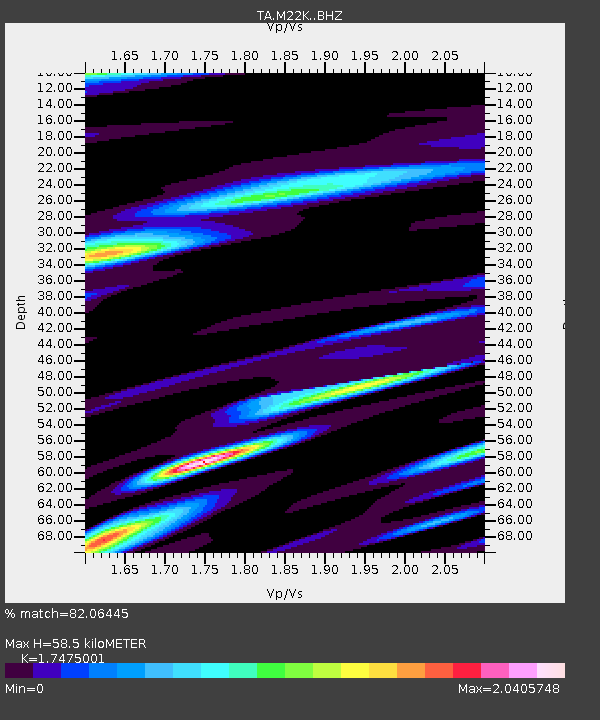
| Estimated Moho Depth: |
58.5 km |
| Estimated Crust Vp/Vs: |
1.75 |
| Assumed Crust Vp: |
6.302 km/s |
| Estimated Crust Vs: |
3.606 km/s |
| Estimated Crust Poisson's Ratio: |
0.26 |
|
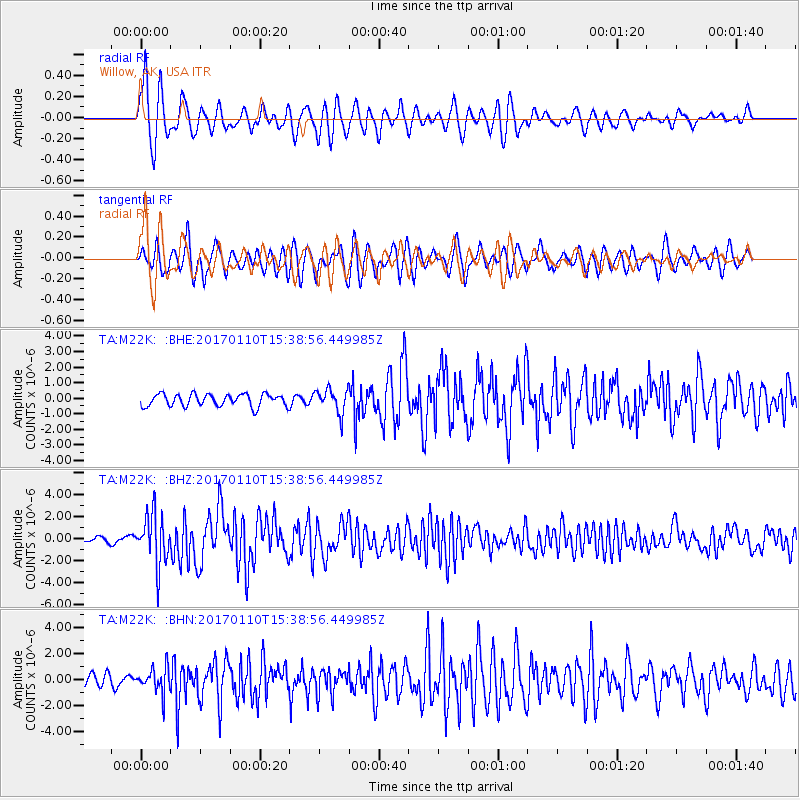
| Radial Match: |
82.06445 % |
| Radial Bump: |
400 |
| Transverse Match: |
79.06242 % |
| Transverse Bump: |
400 |
| SOD ConfigId: |
11737051 |
| Insert Time: |
2019-04-26 14:34:47.776 +0000 |
| GWidth: |
2.5 |
| Max Bumps: |
400 |
| Tol: |
0.001 |
|
Signal To Noise
| Channel | StoN | STA | LTA |
| TA:M22K: :BHZ:20170110T15:38:56.449985Z | 13.282169 | 2.3100688E-6 | 1.7392256E-7 |
| TA:M22K: :BHN:20170110T15:38:56.449985Z | 2.4748433 | 9.539423E-7 | 3.8545562E-7 |
| TA:M22K: :BHE:20170110T15:38:56.449985Z | 1.9895291 | 7.7766526E-7 | 3.9087905E-7 |
| Arrivals |
| Ps | 7.1 SECOND |
| PpPs | 25 SECOND |
| PsPs/PpSs | 32 SECOND |


