You are here: Home > Network List > TA - USArray Transportable Network (new EarthScope stations) Stations List
> Station P17K Kvichak River, AK, USA > Earthquake Result Viewer
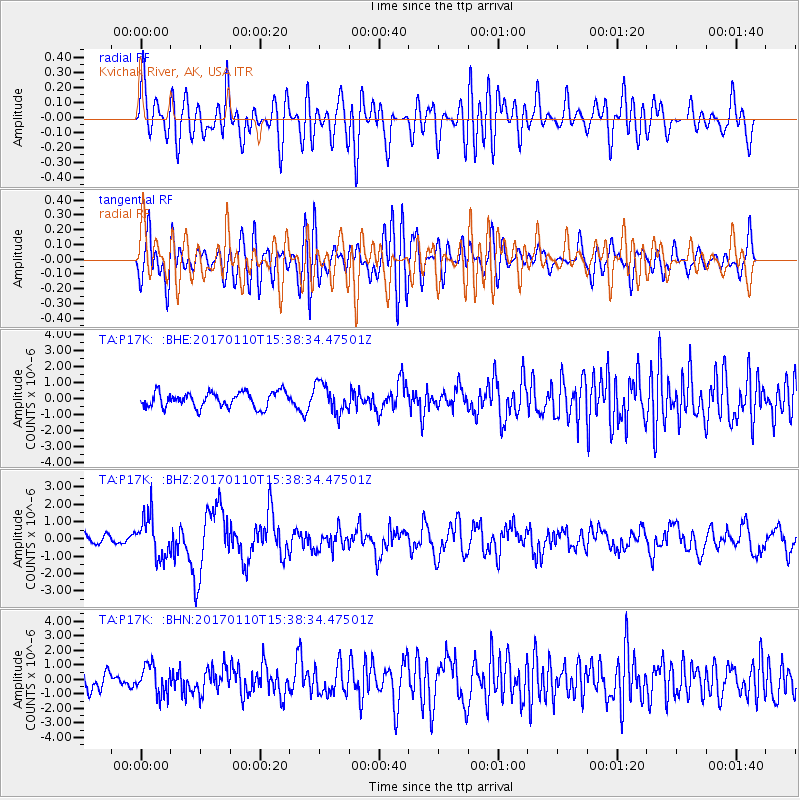
P17K Kvichak River, AK, USA - Earthquake Result Viewer
*The percent match for this event was below the threshold and hence no stack was calculated.
| Earthquake location: |
Solomon Islands |
| Earthquake latitude/longitude: |
-10.1/161.0 |
| Earthquake time(UTC): |
2017/01/10 (010) 15:27:15 GMT |
| Earthquake Depth: |
28 km |
| Earthquake Magnitude: |
6.3 Mww |
| Earthquake Catalog/Contributor: |
NEIC PDE/us |
|
| Network: |
TA USArray Transportable Network (new EarthScope stations) |
| Station: |
P17K Kvichak River, AK, USA |
| Lat/Lon: |
59.20 N/156.44 W |
| Elevation: |
91 m |
|
| Distance: |
77.1 deg |
| Az: |
20.913 deg |
| Baz: |
223.07 deg |
| Ray Param: |
$rayparam |
*The percent match for this event was below the threshold and hence was not used in the summary stack. |
|
| Radial Match: |
61.977932 % |
| Radial Bump: |
400 |
| Transverse Match: |
56.09618 % |
| Transverse Bump: |
400 |
| SOD ConfigId: |
11737051 |
| Insert Time: |
2019-04-26 14:35:04.155 +0000 |
| GWidth: |
2.5 |
| Max Bumps: |
400 |
| Tol: |
0.001 |
|
Signal To Noise
| Channel | StoN | STA | LTA |
| TA:P17K: :BHZ:20170110T15:38:34.47501Z | 3.2089207 | 1.1794715E-6 | 3.6756018E-7 |
| TA:P17K: :BHN:20170110T15:38:34.47501Z | 1.1607324 | 9.761017E-7 | 8.40936E-7 |
| TA:P17K: :BHE:20170110T15:38:34.47501Z | 1.9067168 | 9.1655915E-7 | 4.807002E-7 |
| Arrivals |
| Ps | |
| PpPs | |
| PsPs/PpSs | |


