You are here: Home > Network List > TA - USArray Transportable Network (new EarthScope stations) Stations List
> Station R33M Jennings River, BC, CAN > Earthquake Result Viewer
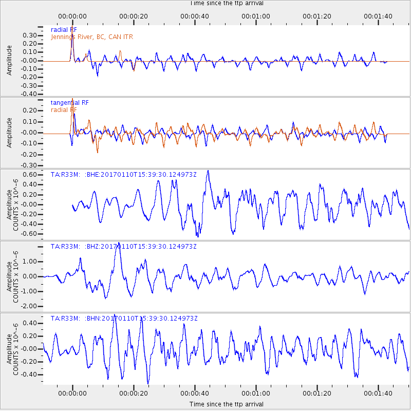
R33M Jennings River, BC, CAN - Earthquake Result Viewer
*The percent match for this event was below the threshold and hence no stack was calculated.
| Earthquake location: |
Solomon Islands |
| Earthquake latitude/longitude: |
-10.1/161.0 |
| Earthquake time(UTC): |
2017/01/10 (010) 15:27:15 GMT |
| Earthquake Depth: |
28 km |
| Earthquake Magnitude: |
6.3 Mww |
| Earthquake Catalog/Contributor: |
NEIC PDE/us |
|
| Network: |
TA USArray Transportable Network (new EarthScope stations) |
| Station: |
R33M Jennings River, BC, CAN |
| Lat/Lon: |
59.39 N/130.97 W |
| Elevation: |
1437 m |
|
| Distance: |
87.8 deg |
| Az: |
28.344 deg |
| Baz: |
246.011 deg |
| Ray Param: |
$rayparam |
*The percent match for this event was below the threshold and hence was not used in the summary stack. |
|
| Radial Match: |
67.76629 % |
| Radial Bump: |
388 |
| Transverse Match: |
48.14106 % |
| Transverse Bump: |
400 |
| SOD ConfigId: |
11737051 |
| Insert Time: |
2019-04-26 14:35:17.131 +0000 |
| GWidth: |
2.5 |
| Max Bumps: |
400 |
| Tol: |
0.001 |
|
Signal To Noise
| Channel | StoN | STA | LTA |
| TA:R33M: :BHZ:20170110T15:39:30.124973Z | 3.6281207 | 5.382098E-7 | 1.4834396E-7 |
| TA:R33M: :BHN:20170110T15:39:30.124973Z | 0.8500142 | 1.04458785E-7 | 1.2289063E-7 |
| TA:R33M: :BHE:20170110T15:39:30.124973Z | 1.8715068 | 2.861014E-7 | 1.5287222E-7 |
| Arrivals |
| Ps | |
| PpPs | |
| PsPs/PpSs | |


