You are here: Home > Network List > UW - Pacific Northwest Regional Seismic Network Stations List
> Station LON Longmire CREST broad-band > Earthquake Result Viewer
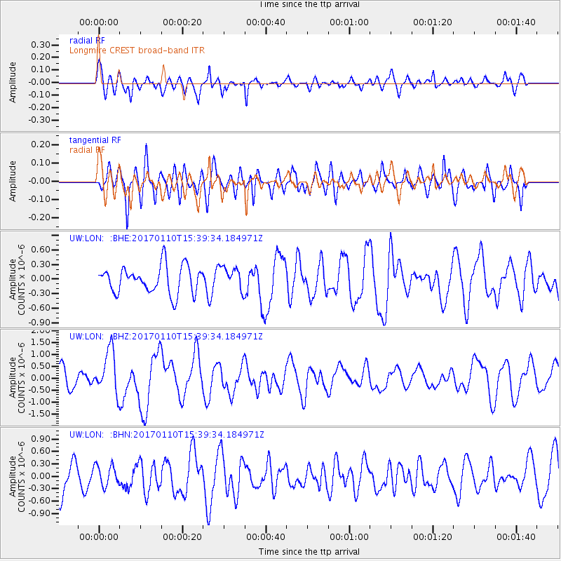
LON Longmire CREST broad-band - Earthquake Result Viewer
*The percent match for this event was below the threshold and hence no stack was calculated.
| Earthquake location: |
Solomon Islands |
| Earthquake latitude/longitude: |
-10.1/161.0 |
| Earthquake time(UTC): |
2017/01/10 (010) 15:27:15 GMT |
| Earthquake Depth: |
28 km |
| Earthquake Magnitude: |
6.3 Mww |
| Earthquake Catalog/Contributor: |
NEIC PDE/us |
|
| Network: |
UW Pacific Northwest Regional Seismic Network |
| Station: |
LON Longmire CREST broad-band |
| Lat/Lon: |
46.75 N/121.81 W |
| Elevation: |
853 m |
|
| Distance: |
88.7 deg |
| Az: |
42.114 deg |
| Baz: |
253.793 deg |
| Ray Param: |
$rayparam |
*The percent match for this event was below the threshold and hence was not used in the summary stack. |
|
| Radial Match: |
64.17876 % |
| Radial Bump: |
400 |
| Transverse Match: |
50.932945 % |
| Transverse Bump: |
400 |
| SOD ConfigId: |
11737051 |
| Insert Time: |
2019-04-26 14:36:00.138 +0000 |
| GWidth: |
2.5 |
| Max Bumps: |
400 |
| Tol: |
0.001 |
|
Signal To Noise
| Channel | StoN | STA | LTA |
| UW:LON: :BHZ:20170110T15:39:34.184971Z | 2.109657 | 9.454273E-7 | 4.4814263E-7 |
| UW:LON: :BHN:20170110T15:39:34.184971Z | 0.72416645 | 2.4641227E-7 | 3.4027022E-7 |
| UW:LON: :BHE:20170110T15:39:34.184971Z | 0.8425824 | 2.3557483E-7 | 2.795867E-7 |
| Arrivals |
| Ps | |
| PpPs | |
| PsPs/PpSs | |


