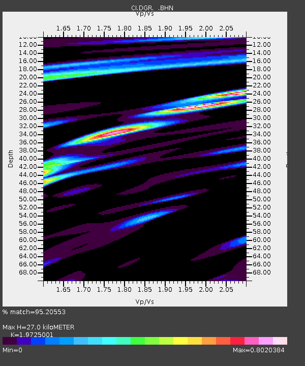
DGR Domenigoni Reservoir, California, USA - Earthquake Result Viewer

Earthquake location: Rat Islands, Aleutian Islands
Earthquake latitude/longitude: 51.6/175.2
Earthquake time(UTC): 1998/08/20 (232) 15:00:08 GMT
Earthquake Depth: 33 km
Earthquake Magnitude: 5.6 MB, 6.0 MS, 6.2 UNKNOWN, 6.2 MW
Earthquake Catalog/Contributor: WHDF/NEIC
Network: CI Caltech Regional Seismic Network
Station: DGR Domenigoni Reservoir, California, USA
Lat/Lon: 33.65 N/117.01 W
Elevation: 609 m
Distance: 51.1 deg
Az: 82.85 deg
Baz: 312.131 deg
Ray Param: 0.06757659
Estimated Moho Depth: 27.0 km
Estimated Crust Vp/Vs: 1.97
Assumed Crust Vp: 6.264 km/s
Estimated Crust Vs: 3.175 km/s
Estimated Crust Poisson's Ratio: 0.33
Radial Match: 95.20553 %
Radial Bump: 386
Transverse Match: 83.63852 %
Transverse Bump: 400
SOD ConfigId: 3787
Insert Time: 2010-03-05 21:29:35.969 +0000
GWidth: 2.5
Max Bumps: 400
Tol: 0.001

Signal To Noise

ChannelStoNSTALTA
CI:DGR: :BHN:19980820T15:08:36.740015Z2.83474232.7849836E-79.824468E-8
CI:DGR: :BHE:19980820T15:08:36.740015Z2.16215832.391259E-71.10595934E-7
CI:DGR: :BHZ:19980820T15:08:36.740015Z4.4016955.8298895E-71.3244647E-7
Arrivals
Ps4.4 SECOND
PpPs12 SECOND
PsPs/PpSs17 SECOND