You are here: Home > Network List > UW - Pacific Northwest Regional Seismic Network Stations List
> Station UMAT Pilot Rock, OR, USA > Earthquake Result Viewer
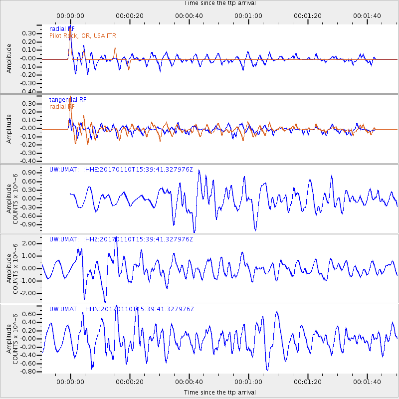
UMAT Pilot Rock, OR, USA - Earthquake Result Viewer
*The percent match for this event was below the threshold and hence no stack was calculated.
| Earthquake location: |
Solomon Islands |
| Earthquake latitude/longitude: |
-10.1/161.0 |
| Earthquake time(UTC): |
2017/01/10 (010) 15:27:15 GMT |
| Earthquake Depth: |
28 km |
| Earthquake Magnitude: |
6.3 Mww |
| Earthquake Catalog/Contributor: |
NEIC PDE/us |
|
| Network: |
UW Pacific Northwest Regional Seismic Network |
| Station: |
UMAT Pilot Rock, OR, USA |
| Lat/Lon: |
45.29 N/118.96 W |
| Elevation: |
1318 m |
|
| Distance: |
90.2 deg |
| Az: |
44.043 deg |
| Baz: |
255.858 deg |
| Ray Param: |
$rayparam |
*The percent match for this event was below the threshold and hence was not used in the summary stack. |
|
| Radial Match: |
78.673874 % |
| Radial Bump: |
373 |
| Transverse Match: |
62.310894 % |
| Transverse Bump: |
400 |
| SOD ConfigId: |
11737051 |
| Insert Time: |
2019-04-26 14:36:07.978 +0000 |
| GWidth: |
2.5 |
| Max Bumps: |
400 |
| Tol: |
0.001 |
|
Signal To Noise
| Channel | StoN | STA | LTA |
| UW:UMAT: :HHZ:20170110T15:39:41.327976Z | 2.1923773 | 1.098207E-6 | 5.0092063E-7 |
| UW:UMAT: :HHN:20170110T15:39:41.327976Z | 1.2760736 | 3.1865767E-7 | 2.4971732E-7 |
| UW:UMAT: :HHE:20170110T15:39:41.327976Z | 1.8353686 | 3.5265262E-7 | 1.9214266E-7 |
| Arrivals |
| Ps | |
| PpPs | |
| PsPs/PpSs | |


