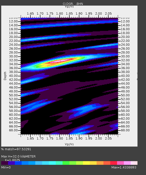
DGR Domenigoni Reservoir, California, USA - Earthquake Result Viewer
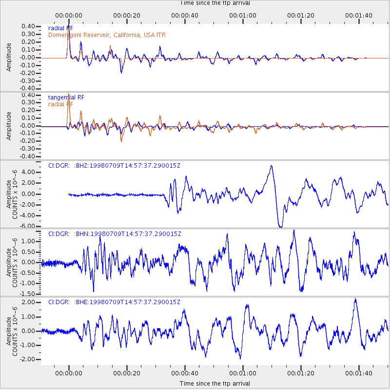
Earthquake location: Kermadec Islands, New Zealand
Earthquake latitude/longitude: -30.5/-179.0
Earthquake time(UTC): 1998/07/09 (190) 14:45:39 GMT
Earthquake Depth: 130 km
Earthquake Magnitude: 6.2 MB, 6.2 MS, 6.9 UNKNOWN, 6.4 ME
Earthquake Catalog/Contributor: WHDF/NEIC
Network: CI Caltech Regional Seismic Network
Station: DGR Domenigoni Reservoir, California, USA
Lat/Lon: 33.65 N/117.01 W
Elevation: 609 m
Distance: 86.6 deg
Az: 47.538 deg
Baz: 229.769 deg
Ray Param: 0.04366644
Estimated Moho Depth: 32.0 km
Estimated Crust Vp/Vs: 1.80
Assumed Crust Vp: 6.264 km/s
Estimated Crust Vs: 3.475 km/s
Estimated Crust Poisson's Ratio: 0.28
Radial Match: 97.53291 %
Radial Bump: 400
Transverse Match: 90.07953 %
Transverse Bump: 400
SOD ConfigId: 3787
Insert Time: 2010-03-05 21:29:39.718 +0000
GWidth: 2.5
Max Bumps: 400
Tol: 0.001

Signal To Noise

ChannelStoNSTALTA
CI:DGR: :BHN:19980709T14:57:37.290015Z1.82067841.5113211E-78.3008686E-8
CI:DGR: :BHE:19980709T14:57:37.290015Z2.58980752.5086587E-79.68666E-8
CI:DGR: :BHZ:19980709T14:57:37.290015Z8.0159887.7273637E-79.639938E-8
Arrivals
Ps4.2 SECOND
PpPs14 SECOND
PsPs/PpSs18 SECOND