You are here: Home > Network List > CI - Caltech Regional Seismic Network Stations List
> Station DGR Domenigoni Reservoir, California, USA > Earthquake Result Viewer
DGR Domenigoni Reservoir, California, USA - Earthquake Result Viewer

| Earthquake location: |
Southeast Of Loyalty Islands |
| Earthquake latitude/longitude: |
-22.3/170.9 |
| Earthquake time(UTC): |
1998/01/04 (004) 06:11:58 GMT |
| Earthquake Depth: |
101 km |
| Earthquake Magnitude: |
6.4 MB, 7.4 UNKNOWN, 7.3 ME |
| Earthquake Catalog/Contributor: |
WHDF/NEIC |
|
| Network: |
CI Caltech Regional Seismic Network |
| Station: |
DGR Domenigoni Reservoir, California, USA |
| Lat/Lon: |
33.65 N/117.01 W |
| Elevation: |
609 m |
|
| Distance: |
88.3 deg |
| Az: |
52.563 deg |
| Baz: |
241.83 deg |
| Ray Param: |
0.042476133 |
| Estimated Moho Depth: |
32.25 km |
| Estimated Crust Vp/Vs: |
1.83 |
| Assumed Crust Vp: |
6.264 km/s |
| Estimated Crust Vs: |
3.432 km/s |
| Estimated Crust Poisson's Ratio: |
0.29 |
|
| Radial Match: |
96.36141 % |
| Radial Bump: |
400 |
| Transverse Match: |
88.03187 % |
| Transverse Bump: |
400 |
| SOD ConfigId: |
3787 |
| Insert Time: |
2010-03-05 21:29:41.365 +0000 |
| GWidth: |
2.5 |
| Max Bumps: |
400 |
| Tol: |
0.001 |
|
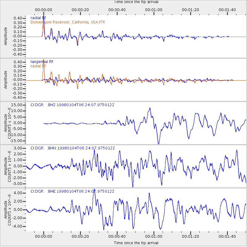
Signal To Noise
| Channel | StoN | STA | LTA |
| CI:DGR: :BHN:19980104T06:24:07.975012Z | 0.8935479 | 2.1253558E-7 | 2.3785583E-7 |
| CI:DGR: :BHE:19980104T06:24:07.975012Z | 1.1275119 | 3.801781E-7 | 3.3718325E-7 |
| CI:DGR: :BHZ:19980104T06:24:07.975012Z | 2.3629706 | 6.6736214E-7 | 2.8242508E-7 |
| Arrivals |
| Ps | 4.3 SECOND |
| PpPs | 14 SECOND |
| PsPs/PpSs | 19 SECOND |


