You are here: Home > Network List > CI - Caltech Regional Seismic Network Stations List
> Station DGR Domenigoni Reservoir, California, USA > Earthquake Result Viewer
DGR Domenigoni Reservoir, California, USA - Earthquake Result Viewer
| Earthquake location: |
Fiji Islands Region |
| Earthquake latitude/longitude: |
-21.6/-176.4 |
| Earthquake time(UTC): |
1998/12/27 (361) 00:38:26 GMT |
| Earthquake Depth: |
144 km |
| Earthquake Magnitude: |
6.1 MB, 6.9 UNKNOWN, 6.6 ME |
| Earthquake Catalog/Contributor: |
WHDF/NEIC |
|
| Network: |
CI Caltech Regional Seismic Network |
| Station: |
DGR Domenigoni Reservoir, California, USA |
| Lat/Lon: |
33.65 N/117.01 W |
| Elevation: |
609 m |
|
| Distance: |
78.9 deg |
| Az: |
47.015 deg |
| Baz: |
234.683 deg |
| Ray Param: |
0.04901385 |
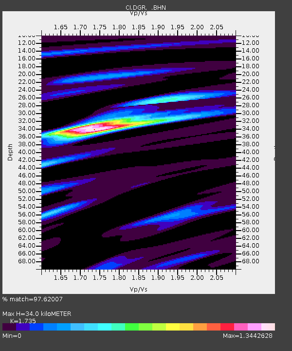
| Estimated Moho Depth: |
34.0 km |
| Estimated Crust Vp/Vs: |
1.74 |
| Assumed Crust Vp: |
6.264 km/s |
| Estimated Crust Vs: |
3.61 km/s |
| Estimated Crust Poisson's Ratio: |
0.25 |
|
| Radial Match: |
97.62007 % |
| Radial Bump: |
388 |
| Transverse Match: |
89.15172 % |
| Transverse Bump: |
400 |
| SOD ConfigId: |
3787 |
| Insert Time: |
2010-03-05 21:30:11.162 +0000 |
| GWidth: |
2.5 |
| Max Bumps: |
400 |
| Tol: |
0.001 |
|

Signal To Noise
| Channel | StoN | STA | LTA |
| CI:DGR: :BHN:19981227T00:49:42.803027Z | 2.2754939 | 1.9774524E-7 | 8.690212E-8 |
| CI:DGR: :BHE:19981227T00:49:42.803027Z | 5.3583536 | 3.8411935E-7 | 7.1686074E-8 |
| CI:DGR: :BHZ:19981227T00:49:42.803027Z | 5.5485415 | 7.8860086E-7 | 1.421276E-7 |
| Arrivals |
| Ps | 4.1 SECOND |
| PpPs | 14 SECOND |
| PsPs/PpSs | 19 SECOND |


