You are here: Home > Network List > TA - USArray Transportable Network (new EarthScope stations) Stations List
> Station G21K Allakaket, AK, USA > Earthquake Result Viewer
G21K Allakaket, AK, USA - Earthquake Result Viewer
*The percent match for this event was below the threshold and hence no stack was calculated.
| Earthquake location: |
South Of Mariana Islands |
| Earthquake latitude/longitude: |
12.2/141.1 |
| Earthquake time(UTC): |
2017/01/11 (011) 14:38:39 GMT |
| Earthquake Depth: |
10 km |
| Earthquake Magnitude: |
5.5 mb |
| Earthquake Catalog/Contributor: |
NEIC PDE/us |
|
| Network: |
TA USArray Transportable Network (new EarthScope stations) |
| Station: |
G21K Allakaket, AK, USA |
| Lat/Lon: |
66.52 N/153.51 W |
| Elevation: |
446 m |
|
| Distance: |
69.2 deg |
| Az: |
22.952 deg |
| Baz: |
252.038 deg |
| Ray Param: |
$rayparam |
*The percent match for this event was below the threshold and hence was not used in the summary stack. |
|
| Radial Match: |
51.82184 % |
| Radial Bump: |
351 |
| Transverse Match: |
29.441786 % |
| Transverse Bump: |
388 |
| SOD ConfigId: |
11737051 |
| Insert Time: |
2019-04-26 14:42:27.292 +0000 |
| GWidth: |
2.5 |
| Max Bumps: |
400 |
| Tol: |
0.001 |
|
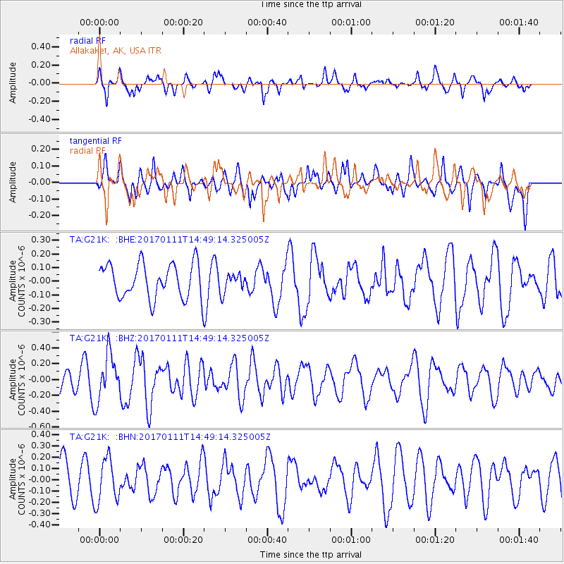
Signal To Noise
| Channel | StoN | STA | LTA |
| TA:G21K: :BHZ:20170111T14:49:14.325005Z | 2.0679576 | 2.8749488E-7 | 1.3902357E-7 |
| TA:G21K: :BHN:20170111T14:49:14.325005Z | 0.8575919 | 1.9195123E-7 | 2.2382584E-7 |
| TA:G21K: :BHE:20170111T14:49:14.325005Z | 0.5427803 | 6.885461E-8 | 1.268554E-7 |
| Arrivals |
| Ps | |
| PpPs | |
| PsPs/PpSs | |


