You are here: Home > Network List > TA - USArray Transportable Network (new EarthScope stations) Stations List
> Station I23K Minto, Yukon-Koyukuk, AK, USA > Earthquake Result Viewer
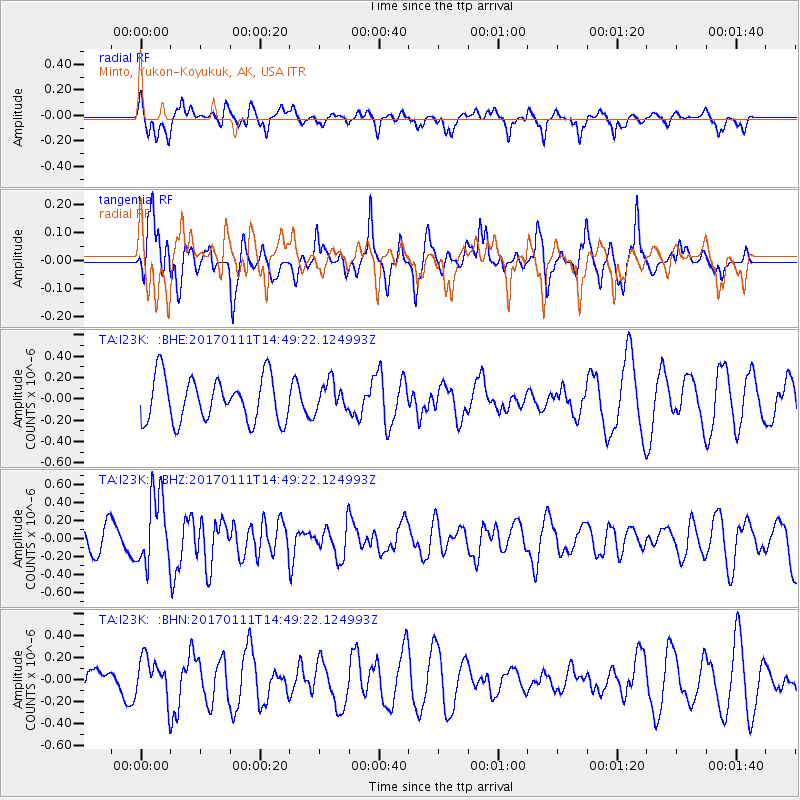
I23K Minto, Yukon-Koyukuk, AK, USA - Earthquake Result Viewer
*The percent match for this event was below the threshold and hence no stack was calculated.
| Earthquake location: |
South Of Mariana Islands |
| Earthquake latitude/longitude: |
12.2/141.1 |
| Earthquake time(UTC): |
2017/01/11 (011) 14:38:39 GMT |
| Earthquake Depth: |
10 km |
| Earthquake Magnitude: |
5.5 mb |
| Earthquake Catalog/Contributor: |
NEIC PDE/us |
|
| Network: |
TA USArray Transportable Network (new EarthScope stations) |
| Station: |
I23K Minto, Yukon-Koyukuk, AK, USA |
| Lat/Lon: |
65.15 N/149.36 W |
| Elevation: |
149 m |
|
| Distance: |
70.4 deg |
| Az: |
24.854 deg |
| Baz: |
256.473 deg |
| Ray Param: |
$rayparam |
*The percent match for this event was below the threshold and hence was not used in the summary stack. |
|
| Radial Match: |
53.114033 % |
| Radial Bump: |
389 |
| Transverse Match: |
45.04228 % |
| Transverse Bump: |
390 |
| SOD ConfigId: |
11737051 |
| Insert Time: |
2019-04-26 14:42:31.803 +0000 |
| GWidth: |
2.5 |
| Max Bumps: |
400 |
| Tol: |
0.001 |
|
Signal To Noise
| Channel | StoN | STA | LTA |
| TA:I23K: :BHZ:20170111T14:49:22.124993Z | 3.2016013 | 3.934041E-7 | 1.228773E-7 |
| TA:I23K: :BHN:20170111T14:49:22.124993Z | 1.1504096 | 1.9335148E-7 | 1.6807186E-7 |
| TA:I23K: :BHE:20170111T14:49:22.124993Z | 0.66539997 | 1.3768789E-7 | 2.0692501E-7 |
| Arrivals |
| Ps | |
| PpPs | |
| PsPs/PpSs | |


