You are here: Home > Network List > TA - USArray Transportable Network (new EarthScope stations) Stations List
> Station O17K Koliganek, Bristol Bay, AK, USA > Earthquake Result Viewer
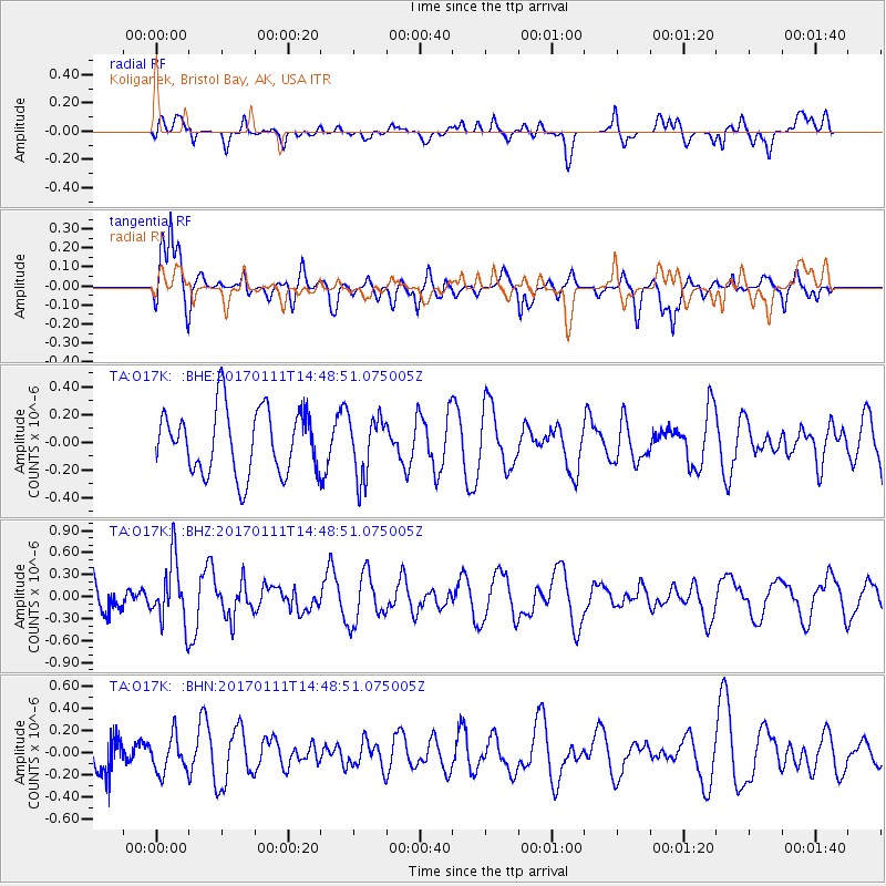
O17K Koliganek, Bristol Bay, AK, USA - Earthquake Result Viewer
*The percent match for this event was below the threshold and hence no stack was calculated.
| Earthquake location: |
South Of Mariana Islands |
| Earthquake latitude/longitude: |
12.2/141.1 |
| Earthquake time(UTC): |
2017/01/11 (011) 14:38:39 GMT |
| Earthquake Depth: |
10 km |
| Earthquake Magnitude: |
5.5 mb |
| Earthquake Catalog/Contributor: |
NEIC PDE/us |
|
| Network: |
TA USArray Transportable Network (new EarthScope stations) |
| Station: |
O17K Koliganek, Bristol Bay, AK, USA |
| Lat/Lon: |
59.77 N/157.09 W |
| Elevation: |
156 m |
|
| Distance: |
65.5 deg |
| Az: |
29.357 deg |
| Baz: |
251.308 deg |
| Ray Param: |
$rayparam |
*The percent match for this event was below the threshold and hence was not used in the summary stack. |
|
| Radial Match: |
49.836193 % |
| Radial Bump: |
400 |
| Transverse Match: |
81.42246 % |
| Transverse Bump: |
400 |
| SOD ConfigId: |
11737051 |
| Insert Time: |
2019-04-26 14:42:42.267 +0000 |
| GWidth: |
2.5 |
| Max Bumps: |
400 |
| Tol: |
0.001 |
|
Signal To Noise
| Channel | StoN | STA | LTA |
| TA:O17K: :BHZ:20170111T14:48:51.075005Z | 1.6373961 | 4.3400087E-7 | 2.6505552E-7 |
| TA:O17K: :BHN:20170111T14:48:51.075005Z | 0.6487061 | 1.624463E-7 | 2.5041587E-7 |
| TA:O17K: :BHE:20170111T14:48:51.075005Z | 0.9316916 | 2.1707089E-7 | 2.3298578E-7 |
| Arrivals |
| Ps | |
| PpPs | |
| PsPs/PpSs | |


