You are here: Home > Network List > CI - Caltech Regional Seismic Network Stations List
> Station DGR Domenigoni Reservoir, California, USA > Earthquake Result Viewer
DGR Domenigoni Reservoir, California, USA - Earthquake Result Viewer
| Earthquake location: |
Kermadec Islands Region |
| Earthquake latitude/longitude: |
-28.6/-177.6 |
| Earthquake time(UTC): |
1999/07/19 (200) 02:17:03 GMT |
| Earthquake Depth: |
39 km |
| Earthquake Magnitude: |
6.3 MB, 6.2 MS, 6.4 MW, 6.3 ME |
| Earthquake Catalog/Contributor: |
WHDF/NEIC |
|
| Network: |
CI Caltech Regional Seismic Network |
| Station: |
DGR Domenigoni Reservoir, California, USA |
| Lat/Lon: |
33.65 N/117.01 W |
| Elevation: |
609 m |
|
| Distance: |
84.4 deg |
| Az: |
46.9 deg |
| Baz: |
230.309 deg |
| Ray Param: |
0.045432027 |
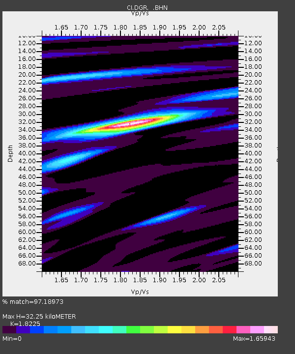
| Estimated Moho Depth: |
32.25 km |
| Estimated Crust Vp/Vs: |
1.82 |
| Assumed Crust Vp: |
6.264 km/s |
| Estimated Crust Vs: |
3.437 km/s |
| Estimated Crust Poisson's Ratio: |
0.28 |
|
| Radial Match: |
97.18973 % |
| Radial Bump: |
388 |
| Transverse Match: |
92.67474 % |
| Transverse Bump: |
400 |
| SOD ConfigId: |
3787 |
| Insert Time: |
2010-03-05 21:30:59.755 +0000 |
| GWidth: |
2.5 |
| Max Bumps: |
400 |
| Tol: |
0.001 |
|

Signal To Noise
| Channel | StoN | STA | LTA |
| CI:DGR: :BHN:19990719T02:29:00.985012Z | 6.402284 | 5.5783363E-7 | 8.713042E-8 |
| CI:DGR: :BHE:19990719T02:29:00.985012Z | 8.636172 | 6.525248E-7 | 7.5557175E-8 |
| CI:DGR: :BHZ:19990719T02:29:00.985012Z | 43.04434 | 2.5033385E-6 | 5.8157205E-8 |
| Arrivals |
| Ps | 4.3 SECOND |
| PpPs | 14 SECOND |
| PsPs/PpSs | 19 SECOND |


