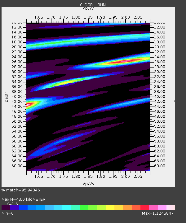
DGR Domenigoni Reservoir, California, USA - Earthquake Result Viewer
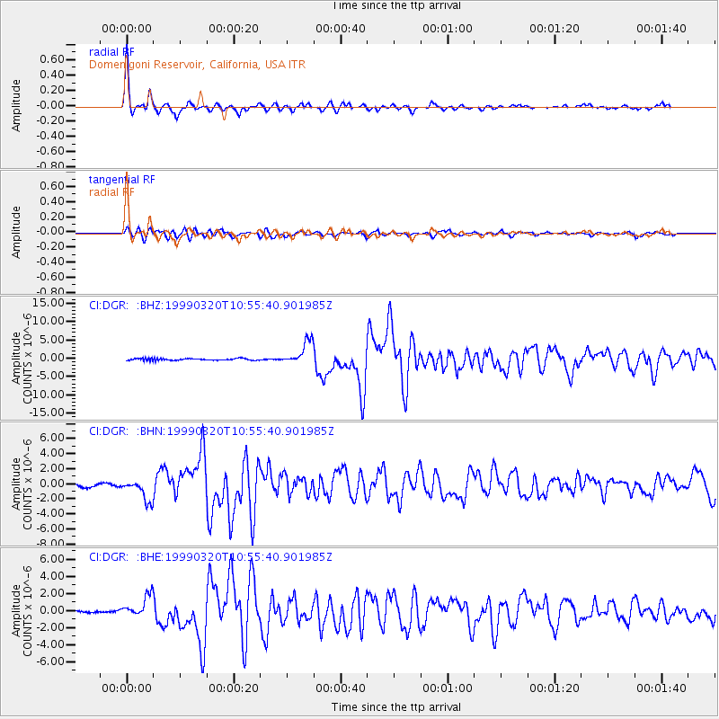
Earthquake location: Andreanof Islands, Aleutian Is.
Earthquake latitude/longitude: 51.6/-177.7
Earthquake time(UTC): 1999/03/20 (079) 10:47:45 GMT
Earthquake Depth: 33 km
Earthquake Magnitude: 6.3 MB, 6.8 MS, 6.9 MW, 6.8 ME
Earthquake Catalog/Contributor: WHDF/NEIC
Network: CI Caltech Regional Seismic Network
Station: DGR Domenigoni Reservoir, California, USA
Lat/Lon: 33.65 N/117.01 W
Elevation: 609 m
Distance: 46.7 deg
Az: 88.058 deg
Baz: 311.626 deg
Ray Param: 0.07042601
Estimated Moho Depth: 43.0 km
Estimated Crust Vp/Vs: 1.60
Assumed Crust Vp: 6.264 km/s
Estimated Crust Vs: 3.915 km/s
Estimated Crust Poisson's Ratio: 0.18
Radial Match: 95.94346 %
Radial Bump: 262
Transverse Match: 83.71524 %
Transverse Bump: 400
SOD ConfigId: 3787
Insert Time: 2010-03-05 21:31:05.594 +0000
GWidth: 2.5
Max Bumps: 400
Tol: 0.001

Signal To Noise

ChannelStoNSTALTA
CI:DGR: :BHN:19990320T10:55:40.901985Z6.54239131.4445853E-62.2080387E-7
CI:DGR: :BHE:19990320T10:55:40.901985Z5.5852251.2805834E-62.2928054E-7
CI:DGR: :BHZ:19990320T10:55:40.901985Z12.9931683.256575E-62.5063747E-7
Arrivals
Ps4.4 SECOND
PpPs17 SECOND
PsPs/PpSs21 SECOND