You are here: Home > Network List > TA - USArray Transportable Network (new EarthScope stations) Stations List
> Station 121A Cookes Peak, Deming, NM, USA > Earthquake Result Viewer
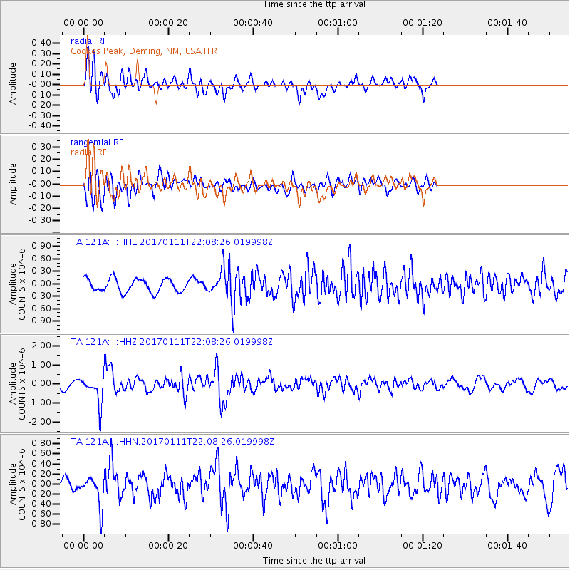
121A Cookes Peak, Deming, NM, USA - Earthquake Result Viewer
*The percent match for this event was below the threshold and hence no stack was calculated.
| Earthquake location: |
Northern Chile |
| Earthquake latitude/longitude: |
-22.8/-69.9 |
| Earthquake time(UTC): |
2017/01/11 (011) 21:58:17 GMT |
| Earthquake Depth: |
69 km |
| Earthquake Magnitude: |
5.9 Mww |
| Earthquake Catalog/Contributor: |
NEIC PDE/us |
|
| Network: |
TA USArray Transportable Network (new EarthScope stations) |
| Station: |
121A Cookes Peak, Deming, NM, USA |
| Lat/Lon: |
32.53 N/107.79 W |
| Elevation: |
1652 m |
|
| Distance: |
65.9 deg |
| Az: |
325.379 deg |
| Baz: |
141.647 deg |
| Ray Param: |
$rayparam |
*The percent match for this event was below the threshold and hence was not used in the summary stack. |
|
| Radial Match: |
66.6343 % |
| Radial Bump: |
400 |
| Transverse Match: |
66.294685 % |
| Transverse Bump: |
400 |
| SOD ConfigId: |
11737051 |
| Insert Time: |
2019-04-26 14:52:46.044 +0000 |
| GWidth: |
2.5 |
| Max Bumps: |
400 |
| Tol: |
0.001 |
|
Signal To Noise
| Channel | StoN | STA | LTA |
| TA:121A: :HHZ:20170111T22:08:26.019998Z | 2.6069965 | 7.538657E-7 | 2.8917023E-7 |
| TA:121A: :HHN:20170111T22:08:26.019998Z | 2.0312958 | 2.9245393E-7 | 1.4397406E-7 |
| TA:121A: :HHE:20170111T22:08:26.019998Z | 1.7342504 | 2.7620226E-7 | 1.5926318E-7 |
| Arrivals |
| Ps | |
| PpPs | |
| PsPs/PpSs | |


