You are here: Home > Network List > CI - Caltech Regional Seismic Network Stations List
> Station DGR Domenigoni Reservoir, California, USA > Earthquake Result Viewer
DGR Domenigoni Reservoir, California, USA - Earthquake Result Viewer
| Earthquake location: |
Kuril Islands |
| Earthquake latitude/longitude: |
46.6/153.3 |
| Earthquake time(UTC): |
2006/11/15 (319) 11:14:13 GMT |
| Earthquake Depth: |
10 km |
| Earthquake Magnitude: |
6.5 MB, 7.8 MS, 8.3 MW, 7.9 MW |
| Earthquake Catalog/Contributor: |
WHDF/NEIC |
|
| Network: |
CI Caltech Regional Seismic Network |
| Station: |
DGR Domenigoni Reservoir, California, USA |
| Lat/Lon: |
33.65 N/117.01 W |
| Elevation: |
609 m |
|
| Distance: |
66.3 deg |
| Az: |
65.653 deg |
| Baz: |
311.131 deg |
| Ray Param: |
0.057715952 |
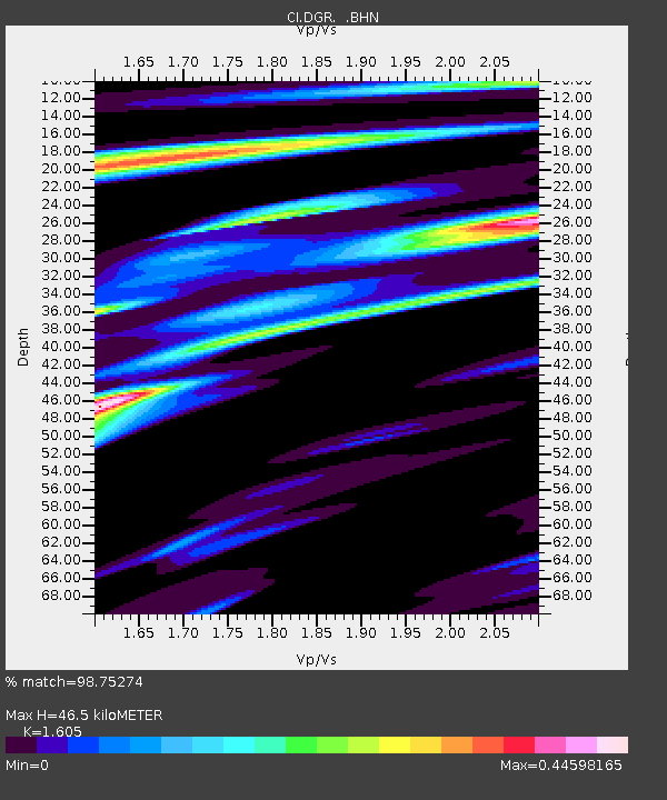
| Estimated Moho Depth: |
46.5 km |
| Estimated Crust Vp/Vs: |
1.61 |
| Assumed Crust Vp: |
6.264 km/s |
| Estimated Crust Vs: |
3.903 km/s |
| Estimated Crust Poisson's Ratio: |
0.18 |
|
| Radial Match: |
98.75274 % |
| Radial Bump: |
245 |
| Transverse Match: |
94.75108 % |
| Transverse Bump: |
400 |
| SOD ConfigId: |
2564 |
| Insert Time: |
2010-03-05 21:33:46.253 +0000 |
| GWidth: |
2.5 |
| Max Bumps: |
400 |
| Tol: |
0.001 |
|

Signal To Noise
| Channel | StoN | STA | LTA |
| CI:DGR: :BHN:20061115T11:24:30.747002Z | 5.5313745 | 1.1573118E-6 | 2.092268E-7 |
| CI:DGR: :BHE:20061115T11:24:30.747002Z | 3.5509245 | 5.7437774E-7 | 1.6175441E-7 |
| CI:DGR: :BHZ:20061115T11:24:30.747002Z | 3.3491206 | 1.6663067E-6 | 4.975356E-7 |
| Arrivals |
| Ps | 4.7 SECOND |
| PpPs | 19 SECOND |
| PsPs/PpSs | 23 SECOND |


