You are here: Home > Network List > OX - North-East Italy Seismic Network Stations List
> Station FUSE Fusea > Earthquake Result Viewer
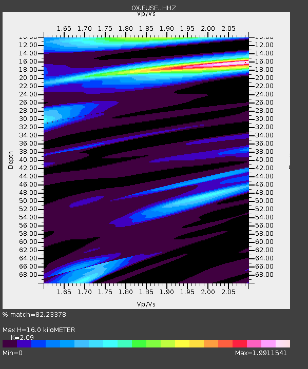
FUSE Fusea - Earthquake Result Viewer
| Earthquake location: |
Madagascar |
| Earthquake latitude/longitude: |
-20.2/46.6 |
| Earthquake time(UTC): |
2017/01/11 (011) 22:06:59 GMT |
| Earthquake Depth: |
8.7 km |
| Earthquake Magnitude: |
5.5 Mww |
| Earthquake Catalog/Contributor: |
NEIC PDE/us |
|
| Network: |
OX North-East Italy Seismic Network |
| Station: |
FUSE Fusea |
| Lat/Lon: |
46.41 N/13.00 E |
| Elevation: |
520 m |
|
| Distance: |
72.9 deg |
| Az: |
336.366 deg |
| Baz: |
147.018 deg |
| Ray Param: |
0.053352248 |
| Estimated Moho Depth: |
16.0 km |
| Estimated Crust Vp/Vs: |
2.09 |
| Assumed Crust Vp: |
6.35 km/s |
| Estimated Crust Vs: |
3.038 km/s |
| Estimated Crust Poisson's Ratio: |
0.35 |
|
| Radial Match: |
82.23378 % |
| Radial Bump: |
400 |
| Transverse Match: |
62.076107 % |
| Transverse Bump: |
400 |
| SOD ConfigId: |
11737051 |
| Insert Time: |
2019-04-26 14:58:08.229 +0000 |
| GWidth: |
2.5 |
| Max Bumps: |
400 |
| Tol: |
0.001 |
|

Signal To Noise
| Channel | StoN | STA | LTA |
| OX:FUSE: :HHZ:20170111T22:17:57.118018Z | 0.7631921 | 5.450996E-7 | 7.142364E-7 |
| OX:FUSE: :HHN:20170111T22:17:57.118018Z | 2.0077407 | 1.0831186E-6 | 5.3947133E-7 |
| OX:FUSE: :HHE:20170111T22:17:57.118018Z | 0.5166476 | 1.5413698E-7 | 2.983407E-7 |
| Arrivals |
| Ps | 2.8 SECOND |
| PpPs | 7.6 SECOND |
| PsPs/PpSs | 10 SECOND |


