You are here: Home > Network List > AZ - ANZA Regional Network Stations List
> Station SMER AZ.SMER > Earthquake Result Viewer
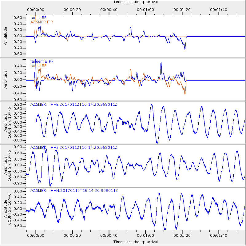
SMER AZ.SMER - Earthquake Result Viewer
*The percent match for this event was below the threshold and hence no stack was calculated.
| Earthquake location: |
Near West Coast Of Colombia |
| Earthquake latitude/longitude: |
6.1/-77.9 |
| Earthquake time(UTC): |
2017/01/12 (012) 16:06:31 GMT |
| Earthquake Depth: |
3.3 km |
| Earthquake Magnitude: |
5.5 mb |
| Earthquake Catalog/Contributor: |
NEIC PDE/us |
|
| Network: |
AZ ANZA Regional Network |
| Station: |
SMER AZ.SMER |
| Lat/Lon: |
33.46 N/117.17 W |
| Elevation: |
355 m |
|
| Distance: |
45.5 deg |
| Az: |
312.105 deg |
| Baz: |
118.044 deg |
| Ray Param: |
$rayparam |
*The percent match for this event was below the threshold and hence was not used in the summary stack. |
|
| Radial Match: |
65.82142 % |
| Radial Bump: |
400 |
| Transverse Match: |
74.656815 % |
| Transverse Bump: |
400 |
| SOD ConfigId: |
11737051 |
| Insert Time: |
2019-04-26 15:00:28.296 +0000 |
| GWidth: |
2.5 |
| Max Bumps: |
400 |
| Tol: |
0.001 |
|
Signal To Noise
| Channel | StoN | STA | LTA |
| AZ:SMER: :HHZ:20170112T16:14:20.968011Z | 2.998987 | 6.5220075E-7 | 2.1747368E-7 |
| AZ:SMER: :HHN:20170112T16:14:20.968011Z | 0.48577917 | 1.4325707E-7 | 2.949016E-7 |
| AZ:SMER: :HHE:20170112T16:14:20.968011Z | 0.8010858 | 2.681596E-7 | 3.3474512E-7 |
| Arrivals |
| Ps | |
| PpPs | |
| PsPs/PpSs | |


