You are here: Home > Network List > CI - Caltech Regional Seismic Network Stations List
> Station DGR Domenigoni Reservoir, California, USA > Earthquake Result Viewer
DGR Domenigoni Reservoir, California, USA - Earthquake Result Viewer
| Earthquake location: |
Near Coast Of Northern Chile |
| Earthquake latitude/longitude: |
-27.0/-71.0 |
| Earthquake time(UTC): |
2006/04/30 (120) 19:17:17 GMT |
| Earthquake Depth: |
27 km |
| Earthquake Magnitude: |
6.0 MB, 6.4 MS, 6.7 MW, 6.6 MW |
| Earthquake Catalog/Contributor: |
WHDF/NEIC |
|
| Network: |
CI Caltech Regional Seismic Network |
| Station: |
DGR Domenigoni Reservoir, California, USA |
| Lat/Lon: |
33.65 N/117.01 W |
| Elevation: |
609 m |
|
| Distance: |
74.5 deg |
| Az: |
321.448 deg |
| Baz: |
138.199 deg |
| Ray Param: |
0.052260246 |
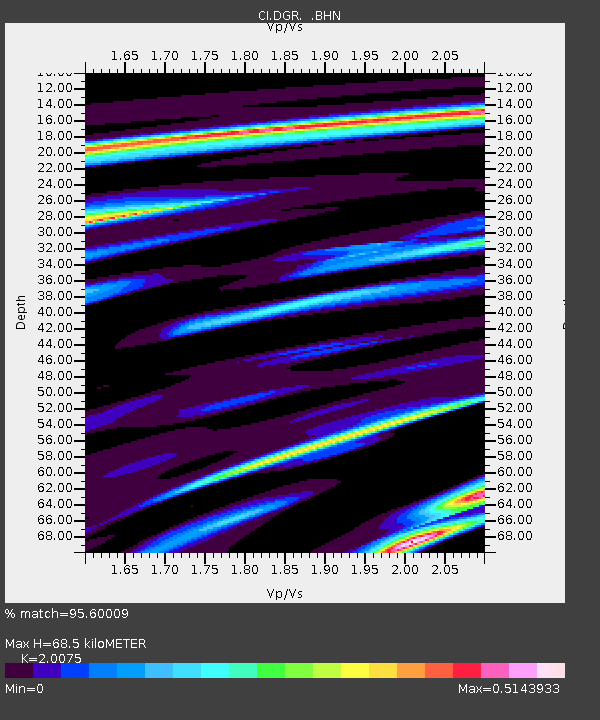
| Estimated Moho Depth: |
68.5 km |
| Estimated Crust Vp/Vs: |
2.01 |
| Assumed Crust Vp: |
6.264 km/s |
| Estimated Crust Vs: |
3.12 km/s |
| Estimated Crust Poisson's Ratio: |
0.33 |
|
| Radial Match: |
95.60009 % |
| Radial Bump: |
293 |
| Transverse Match: |
93.29701 % |
| Transverse Bump: |
400 |
| SOD ConfigId: |
2669 |
| Insert Time: |
2010-03-05 21:34:31.746 +0000 |
| GWidth: |
2.5 |
| Max Bumps: |
400 |
| Tol: |
0.001 |
|

Signal To Noise
| Channel | StoN | STA | LTA |
| CI:DGR: :BHN:20060430T19:28:22.122009Z | 0.6305369 | 8.736218E-8 | 1.3855204E-7 |
| CI:DGR: :BHE:20060430T19:28:22.124023Z | 1.9352849 | 1.1955701E-7 | 6.177747E-8 |
| CI:DGR: :BHZ:20060430T19:28:22.124023Z | 2.7106867 | 2.6345123E-7 | 9.718985E-8 |
| Arrivals |
| Ps | 11 SECOND |
| PpPs | 32 SECOND |
| PsPs/PpSs | 43 SECOND |


