You are here: Home > Network List > TA - USArray Transportable Network (new EarthScope stations) Stations List
> Station G23K Bananza Creek, AK, USA > Earthquake Result Viewer
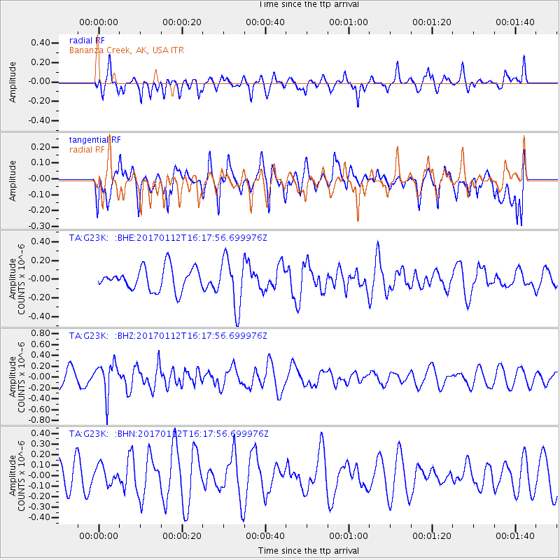
G23K Bananza Creek, AK, USA - Earthquake Result Viewer
*The percent match for this event was below the threshold and hence no stack was calculated.
| Earthquake location: |
Near West Coast Of Colombia |
| Earthquake latitude/longitude: |
6.1/-77.9 |
| Earthquake time(UTC): |
2017/01/12 (012) 16:06:31 GMT |
| Earthquake Depth: |
3.3 km |
| Earthquake Magnitude: |
5.5 mb |
| Earthquake Catalog/Contributor: |
NEIC PDE/us |
|
| Network: |
TA USArray Transportable Network (new EarthScope stations) |
| Station: |
G23K Bananza Creek, AK, USA |
| Lat/Lon: |
66.71 N/150.02 W |
| Elevation: |
746 m |
|
| Distance: |
77.4 deg |
| Az: |
337.192 deg |
| Baz: |
104.171 deg |
| Ray Param: |
$rayparam |
*The percent match for this event was below the threshold and hence was not used in the summary stack. |
|
| Radial Match: |
48.390957 % |
| Radial Bump: |
400 |
| Transverse Match: |
41.30547 % |
| Transverse Bump: |
400 |
| SOD ConfigId: |
11737051 |
| Insert Time: |
2019-04-26 15:06:50.490 +0000 |
| GWidth: |
2.5 |
| Max Bumps: |
400 |
| Tol: |
0.001 |
|
Signal To Noise
| Channel | StoN | STA | LTA |
| TA:G23K: :BHZ:20170112T16:17:56.699976Z | 2.1616247 | 2.981237E-7 | 1.3791649E-7 |
| TA:G23K: :BHN:20170112T16:17:56.699976Z | 0.42116034 | 8.549368E-8 | 2.0299555E-7 |
| TA:G23K: :BHE:20170112T16:17:56.699976Z | 2.3212354 | 2.7404113E-7 | 1.1805831E-7 |
| Arrivals |
| Ps | |
| PpPs | |
| PsPs/PpSs | |


