You are here: Home > Network List > TA - USArray Transportable Network (new EarthScope stations) Stations List
> Station P17K Kvichak River, AK, USA > Earthquake Result Viewer
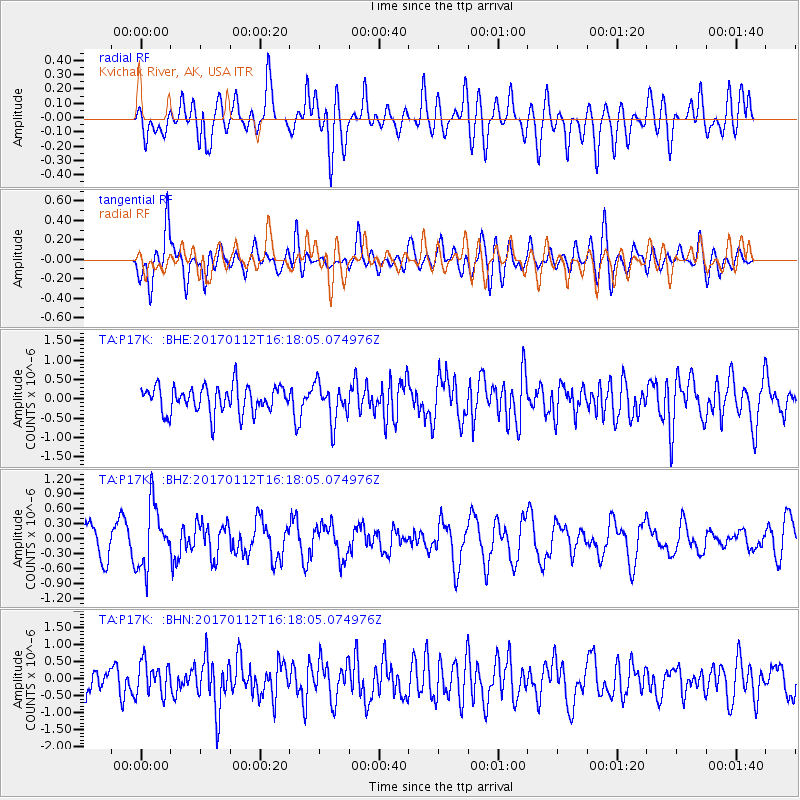
P17K Kvichak River, AK, USA - Earthquake Result Viewer
*The percent match for this event was below the threshold and hence no stack was calculated.
| Earthquake location: |
Near West Coast Of Colombia |
| Earthquake latitude/longitude: |
6.1/-77.9 |
| Earthquake time(UTC): |
2017/01/12 (012) 16:06:31 GMT |
| Earthquake Depth: |
3.3 km |
| Earthquake Magnitude: |
5.5 mb |
| Earthquake Catalog/Contributor: |
NEIC PDE/us |
|
| Network: |
TA USArray Transportable Network (new EarthScope stations) |
| Station: |
P17K Kvichak River, AK, USA |
| Lat/Lon: |
59.20 N/156.44 W |
| Elevation: |
91 m |
|
| Distance: |
78.9 deg |
| Az: |
329.078 deg |
| Baz: |
96.787 deg |
| Ray Param: |
$rayparam |
*The percent match for this event was below the threshold and hence was not used in the summary stack. |
|
| Radial Match: |
61.048286 % |
| Radial Bump: |
400 |
| Transverse Match: |
59.691204 % |
| Transverse Bump: |
400 |
| SOD ConfigId: |
11737051 |
| Insert Time: |
2019-04-26 15:07:07.999 +0000 |
| GWidth: |
2.5 |
| Max Bumps: |
400 |
| Tol: |
0.001 |
|
Signal To Noise
| Channel | StoN | STA | LTA |
| TA:P17K: :BHZ:20170112T16:18:05.074976Z | 2.4774208 | 6.2545774E-7 | 2.5246328E-7 |
| TA:P17K: :BHN:20170112T16:18:05.074976Z | 1.0779325 | 4.8651486E-7 | 4.5134075E-7 |
| TA:P17K: :BHE:20170112T16:18:05.074976Z | 1.4150763 | 4.8659547E-7 | 3.438652E-7 |
| Arrivals |
| Ps | |
| PpPs | |
| PsPs/PpSs | |


