You are here: Home > Network List > TA - USArray Transportable Network (new EarthScope stations) Stations List
> Station Q24A Divide, CO, USA > Earthquake Result Viewer
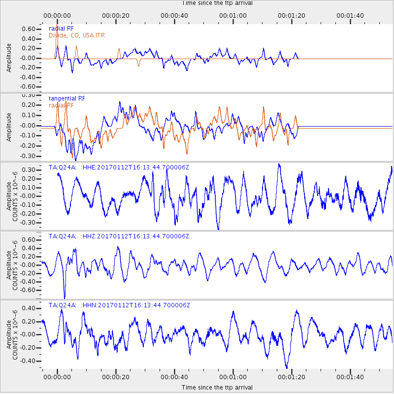
Q24A Divide, CO, USA - Earthquake Result Viewer
*The percent match for this event was below the threshold and hence no stack was calculated.
| Earthquake location: |
Near West Coast Of Colombia |
| Earthquake latitude/longitude: |
6.1/-77.9 |
| Earthquake time(UTC): |
2017/01/12 (012) 16:06:31 GMT |
| Earthquake Depth: |
3.3 km |
| Earthquake Magnitude: |
5.5 mb |
| Earthquake Catalog/Contributor: |
NEIC PDE/us |
|
| Network: |
TA USArray Transportable Network (new EarthScope stations) |
| Station: |
Q24A Divide, CO, USA |
| Lat/Lon: |
38.96 N/105.15 W |
| Elevation: |
2775 m |
|
| Distance: |
41.0 deg |
| Az: |
327.055 deg |
| Baz: |
136.073 deg |
| Ray Param: |
$rayparam |
*The percent match for this event was below the threshold and hence was not used in the summary stack. |
|
| Radial Match: |
46.928967 % |
| Radial Bump: |
400 |
| Transverse Match: |
41.46632 % |
| Transverse Bump: |
400 |
| SOD ConfigId: |
11737051 |
| Insert Time: |
2019-04-26 15:07:11.560 +0000 |
| GWidth: |
2.5 |
| Max Bumps: |
400 |
| Tol: |
0.001 |
|
Signal To Noise
| Channel | StoN | STA | LTA |
| TA:Q24A: :HHZ:20170112T16:13:44.700006Z | 1.9177728 | 2.731166E-7 | 1.4241343E-7 |
| TA:Q24A: :HHN:20170112T16:13:44.700006Z | 1.414521 | 2.0196512E-7 | 1.4277987E-7 |
| TA:Q24A: :HHE:20170112T16:13:44.700006Z | 1.4426687 | 1.7784359E-7 | 1.2327403E-7 |
| Arrivals |
| Ps | |
| PpPs | |
| PsPs/PpSs | |


