You are here: Home > Network List > CI - Caltech Regional Seismic Network Stations List
> Station DGR Domenigoni Reservoir, California, USA > Earthquake Result Viewer
DGR Domenigoni Reservoir, California, USA - Earthquake Result Viewer
| Earthquake location: |
Bonin Islands, Japan Region |
| Earthquake latitude/longitude: |
28.9/139.6 |
| Earthquake time(UTC): |
2000/08/06 (219) 07:27:12 GMT |
| Earthquake Depth: |
395 km |
| Earthquake Magnitude: |
6.3 MB, 7.3 MW, 7.3 MW |
| Earthquake Catalog/Contributor: |
WHDF/NEIC |
|
| Network: |
CI Caltech Regional Seismic Network |
| Station: |
DGR Domenigoni Reservoir, California, USA |
| Lat/Lon: |
33.65 N/117.01 W |
| Elevation: |
609 m |
|
| Distance: |
84.6 deg |
| Az: |
54.587 deg |
| Baz: |
301.012 deg |
| Ray Param: |
0.04434512 |
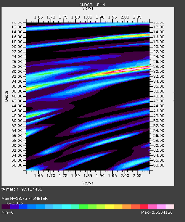
| Estimated Moho Depth: |
28.75 km |
| Estimated Crust Vp/Vs: |
2.04 |
| Assumed Crust Vp: |
6.264 km/s |
| Estimated Crust Vs: |
3.078 km/s |
| Estimated Crust Poisson's Ratio: |
0.34 |
|
| Radial Match: |
97.114456 % |
| Radial Bump: |
320 |
| Transverse Match: |
81.14384 % |
| Transverse Bump: |
400 |
| SOD ConfigId: |
3787 |
| Insert Time: |
2010-03-05 21:35:29.400 +0000 |
| GWidth: |
2.5 |
| Max Bumps: |
400 |
| Tol: |
0.001 |
|
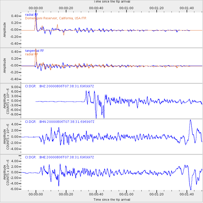
Signal To Noise
| Channel | StoN | STA | LTA |
| CI:DGR: :BHN:20000806T07:38:31.696997Z | 8.090952 | 4.918201E-7 | 6.0786434E-8 |
| CI:DGR: :BHE:20000806T07:38:31.696997Z | 8.299574 | 7.029266E-7 | 8.469431E-8 |
| CI:DGR: :BHZ:20000806T07:38:31.696997Z | 23.078342 | 2.4586175E-6 | 1.0653355E-7 |
| Arrivals |
| Ps | 4.8 SECOND |
| PpPs | 14 SECOND |
| PsPs/PpSs | 19 SECOND |


