You are here: Home > Network List > 9G - Impact of Supraglacial Lakes on Ice-Shelf Stability Stations List
> Station BB02 Pegasus Road mile 8 > Earthquake Result Viewer
BB02 Pegasus Road mile 8 - Earthquake Result Viewer
| Earthquake location: |
Northern Molucca Sea |
| Earthquake latitude/longitude: |
0.0/125.1 |
| Earthquake time(UTC): |
2017/01/13 (013) 16:39:25 GMT |
| Earthquake Depth: |
46 km |
| Earthquake Magnitude: |
5.7 mb |
| Earthquake Catalog/Contributor: |
NEIC PDE/us |
|
| Network: |
9G Impact of Supraglacial Lakes on Ice-Shelf Stability |
| Station: |
BB02 Pegasus Road mile 8 |
| Lat/Lon: |
77.92 S/166.90 E |
| Elevation: |
16 m |
|
| Distance: |
81.0 deg |
| Az: |
171.821 deg |
| Baz: |
317.524 deg |
| Ray Param: |
0.047815762 |
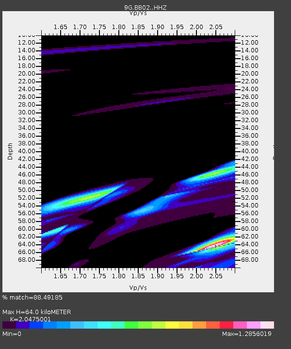
| Estimated Moho Depth: |
64.0 km |
| Estimated Crust Vp/Vs: |
2.05 |
| Assumed Crust Vp: |
6.183 km/s |
| Estimated Crust Vs: |
3.02 km/s |
| Estimated Crust Poisson's Ratio: |
0.34 |
|
| Radial Match: |
88.49185 % |
| Radial Bump: |
400 |
| Transverse Match: |
74.38372 % |
| Transverse Bump: |
400 |
| SOD ConfigId: |
11737051 |
| Insert Time: |
2019-04-26 15:09:38.675 +0000 |
| GWidth: |
2.5 |
| Max Bumps: |
400 |
| Tol: |
0.001 |
|

Signal To Noise
| Channel | StoN | STA | LTA |
| 9G:BB02: :HHZ:20170113T16:51:04.325015Z | 1.4601146 | 3.343167E-5 | 2.2896606E-5 |
| 9G:BB02: :HHN:20170113T16:51:04.325015Z | 2.6086056 | 1.8608485E-5 | 7.1334985E-6 |
| 9G:BB02: :HHE:20170113T16:51:04.325015Z | 9.383883 | 6.543073E-5 | 6.9726707E-6 |
| Arrivals |
| Ps | 11 SECOND |
| PpPs | 31 SECOND |
| PsPs/PpSs | 42 SECOND |


