You are here: Home > Network List > TA - USArray Transportable Network (new EarthScope stations) Stations List
> Station F24K Squaw Lake, AK, USA > Earthquake Result Viewer
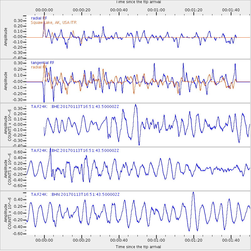
F24K Squaw Lake, AK, USA - Earthquake Result Viewer
*The percent match for this event was below the threshold and hence no stack was calculated.
| Earthquake location: |
Northern Molucca Sea |
| Earthquake latitude/longitude: |
0.0/125.1 |
| Earthquake time(UTC): |
2017/01/13 (013) 16:39:25 GMT |
| Earthquake Depth: |
46 km |
| Earthquake Magnitude: |
5.7 mb |
| Earthquake Catalog/Contributor: |
NEIC PDE/us |
|
| Network: |
TA USArray Transportable Network (new EarthScope stations) |
| Station: |
F24K Squaw Lake, AK, USA |
| Lat/Lon: |
67.52 N/147.89 W |
| Elevation: |
736 m |
|
| Distance: |
88.8 deg |
| Az: |
22.591 deg |
| Baz: |
267.286 deg |
| Ray Param: |
$rayparam |
*The percent match for this event was below the threshold and hence was not used in the summary stack. |
|
| Radial Match: |
53.43662 % |
| Radial Bump: |
400 |
| Transverse Match: |
61.229324 % |
| Transverse Bump: |
381 |
| SOD ConfigId: |
11737051 |
| Insert Time: |
2019-04-26 15:11:41.045 +0000 |
| GWidth: |
2.5 |
| Max Bumps: |
400 |
| Tol: |
0.001 |
|
Signal To Noise
| Channel | StoN | STA | LTA |
| TA:F24K: :BHZ:20170113T16:51:43.500002Z | 2.1414888 | 3.148678E-7 | 1.4703218E-7 |
| TA:F24K: :BHN:20170113T16:51:43.500002Z | 1.6204484 | 2.0871562E-7 | 1.2880115E-7 |
| TA:F24K: :BHE:20170113T16:51:43.500002Z | 1.1289395 | 1.0947856E-7 | 9.69747E-8 |
| Arrivals |
| Ps | |
| PpPs | |
| PsPs/PpSs | |


